Willamette Project’s 50 Year Anniversary: Flooding and Reallocation

The year 2019 marks the 50th anniversary of the Willamette Valley Project, a tumultuous time in the history of the project. These dams are operated by the United States Army Corp of Engineers’ (“Corp”) Portland District, which utilizes 13 dams to prevent flooding and provide water storage for various water users and aquatic species in Western Oregon. (https://www.nwp.usace.army.mil/Locations/Willamette-Valley/) Since their construction, flooding like that seen in the Christmas Flood of 1964 has been rare. This April, the Willamette Valley saw substantial flooding as an “atmospheric river” overwhelmed the capacity of the dams, forcing the Corp release water at historic rates to prevent overtopping of the dams. (https://www.statesmanjournal.com/story/news/2019/04/07/oregon-flooding-willamette-river-santiam-river-eugene-salem/3393877002/). As these dams were created specifically to prevent flooding, what went wrong?
The various interests in water stored in these dams leads to considerable controversy over how to operate the Willamette Valley Project dams. Combined, these dams hold 1.6 million acre-feet in the summer months for various uses including municipal, irrigation, and hydropower. The controversy in operations relates to these uses. For example, storing additional water in the dams benefits electricity production and recreational boating uses (requiring high lake levels), but harms aquatic species and irrigators. Releasing the stored water during the summer reduces electricity production and leaves little for migrating salmon in the fall, but provides irrigation for many Willamette Valley farms. The Corp is left to balance these competing interests for the use of “conservation storage” (the water stored for use in the summer months).
Recently, the Corp considered reallocating water between theses interests, which focuses primarily on how to use the water stored in the summer months. We have discussed this potential reallocation here: https://www.water-law.com/study-willamette-valley-project-reallocation/. The allocations of uses between these interests has not been reconsidered since the original construction of the dams. (The Capital Press recently covered the discussion here: https://bit.ly/2IyzCfr). While the reallocation will determine how stored water is used, the dam regulation curves determine when the dams are emptied and space is made for flood mitigation.

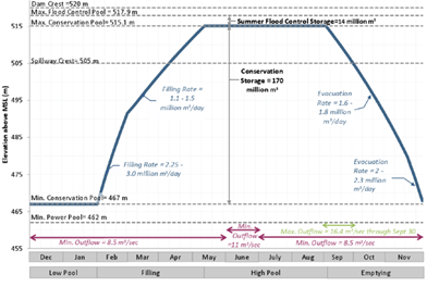
Flood control is another “interest” competing for the Corp’s attention and a reservior’s capacity. In the winter, these dams are emptied to allow the space to be used to absorb the brunt of storms. In the spring, the dams are gradually refilled up to their maximum operating capacity during the summer, for use for power and water storage. The image to the right depicts the regulation curve for the Cougar Reservoir, which stores water from the South Fork of the McKenzie River. The Corp developed the operating curve for the Cougar Reservoir in 1964, located in the Cougar Reservoir Regulation Manual. (https://bit.ly/2PtpANm). Each dam has its own manual, determining how and when water is released from the reservoir. While the allocation determines how stored water is used, the “conservation storage” hump determines when, how much, and for how long the dams are filled.

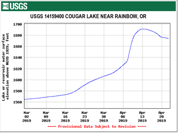
This year’s atmospheric river struck on April 7-8, 2019, just as these dams were being filled for use as summer storage. While not at “max conservation pool” level (occurring around May 1), the dams were approaching their upper limits. Cougar Reservoir, for example, was at around 494 meters (1620 feet) before the storm and according to its operating curve, the reservoir should have been around 500 meters (1640 feet) (seen in the graph to the right, reservoir levels are measured by elevation to sea level, not depth). After April 12, 2019, the South Fork of the Willamette River discharged between 3,000 and 5,000 cubic feet per second (“cfs”) compared to its typical average of about 400-800 cfs at this time. (https://on.doi.gov/2Izcf5n). By April 13, 2019, Cougar Reservoir levels had shot up to nearly 515 meters (1690 feet), the maximum summer flood control level shown in the regulation curve above, several weeks early. By releasing record volumes of water from these dams, and using up any remaining storage capacity still available, the Corp prevented overtopping of the dams at the cost of downstream riparian landowners.
Water releases over this period prevented an overflow, but opens the question of whether more flood control space may be required for spring storms in the future. When the reservoirs are full late in the season, the Corp has little choice but to open the gates, flooding downstream homes, farms, and cities. Calls for changing the Corp’s dam regulation curves may also come alongside the calls to reallocate stored water, adding even more controversy for the Willamette Valley Project near its 50th birthday.
Make sure to stay tuned to Schroeder Law Offices’ Water Blog for more news that may affect you!