Willamette Project’s 50 Year Anniversary: Flooding and Reallocation

The year 2019 marks the 50th anniversary of the Willamette Valley Project, a tumultuous time in the history of the project. These dams are operated by the United States Army Corp of Engineers’ (“Corp”) Portland District, which utilizes 13 dams to prevent flooding and provide water storage for various water users and aquatic species in Western Oregon. (https://www.nwp.usace.army.mil/Locations/Willamette-Valley/) Since their construction, flooding like that seen in the Christmas Flood of 1964 has been rare. This April, the Willamette Valley saw substantial flooding as an “atmospheric river” overwhelmed the capacity of the dams, forcing the Corp release water at historic rates to prevent overtopping of the dams. (https://www.statesmanjournal.com/story/news/2019/04/07/oregon-flooding-willamette-river-santiam-river-eugene-salem/3393877002/). As these dams were created specifically to prevent flooding, what went wrong?

The various interests in water stored in these dams leads to considerable controversy over how to operate the Willamette Valley Project dams. Combined, these dams hold 1.6 million acre-feet in the summer months for various uses including municipal, irrigation, and hydropower. The controversy in operations relates to these uses. For example, storing additional water in the dams benefits electricity production and recreational boating uses (requiring high lake levels), but harms aquatic species and irrigators. Releasing the stored water during the summer reduces electricity production and leaves little for migrating salmon in the fall, but provides irrigation for many Willamette Valley farms. The Corp is left to balance these competing interests for the use of “conservation storage” (the water stored for use in the summer months).

Recently, the Corp considered reallocating water between theses interests, which focuses primarily on how to use the water stored in the summer months. We have discussed this potential reallocation here: https://www.water-law.com/study-willamette-valley-project-reallocation/. The allocations of uses between these interests has not been reconsidered since the original construction of the dams. (The Capital Press recently covered the discussion here: https://bit.ly/2IyzCfr). While the reallocation will determine how stored water is used, the dam regulation curves determine when the dams are emptied and space is made for flood mitigation.
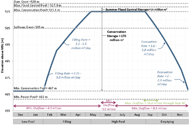
Flood control is another “interest” competing for the Corp’s attention and a reservior’s capacity. In the winter, these dams are emptied to allow the space to be used to absorb the brunt of storms. In the spring, the dams are gradually refilled up to their maximum operating capacity during the summer, for use for power and water storage. The image to the right depicts the regulation curve for the Cougar Reservoir, which stores water from the South Fork of the McKenzie River. The Corp developed the operating curve for the Cougar Reservoir in 1964, located in the Cougar Reservoir Regulation Manual. (https://bit.ly/2PtpANm). Each dam has its own manual, determining how and when water is released from the reservoir. While the allocation determines how stored water is used, the “conservation storage” hump determines when, how much, and for how long the dams are filled.
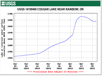
This year’s atmospheric river struck on April 7-8, 2019, just as these dams were being filled for use as summer storage. While not at “max conservation pool” level (occurring around May 1), the dams were approaching their upper limits. Cougar Reservoir, for example, was at around 494 meters (1620 feet) before the storm and according to its operating curve, the reservoir should have been around 500 meters (1640 feet) (seen in the graph to the right, reservoir levels are measured by elevation to sea level, not depth). After April 12, 2019, the South Fork of the Willamette River discharged between 3,000 and 5,000 cubic feet per second (“cfs”) compared to its typical average of about 400-800 cfs at this time. (https://on.doi.gov/2Izcf5n). By April 13, 2019, Cougar Reservoir levels had shot up to nearly 515 meters (1690 feet), the maximum summer flood control level shown in the regulation curve above, several weeks early. By releasing record volumes of water from these dams, and using up any remaining storage capacity still available, the Corp prevented overtopping of the dams at the cost of downstream riparian landowners.

Water releases over this period prevented an overflow, but opens the question of whether more flood control space may be required for spring storms in the future. When the reservoirs are full late in the season, the Corp has little choice but to open the gates, flooding downstream homes, farms, and cities. Calls for changing the Corp’s dam regulation curves may also come alongside the calls to reallocate stored water, adding even more controversy for the Willamette Valley Project near its 50th birthday.

Make sure to stay tuned to Schroeder Law Offices’ Water Blog for more news that may affect you!


Temporary Hold on Upper Klamath Basin Well Regulation through Proposed Rulemaking

Upper Klamath Basin Well Regulation through Proposed Rulemaking

            The Oregon Water Resources Department (“OWRD”) will present proposed temporary rules to the Water Resource Commission that would place a temporary hold on Upper Klamath Basin well regulation for two years, during which time OWRD would only regulate off wells within 500 feet of surface water sources in response to validated calls for water. Since the administrative phase of the Klamath Basin Adjudication concluded in 2013, groundwater users have challenged OWRD’s application of Oregon’s conjunctive management rules to wells in the Klamath Basin. The deluge of litigation has cost the OWRD millions of dollars and does not appear to have an end in sight.

            OWRD may be offering a temporary truce to groundwater users while the agency reviews and determines a “longer term approach” to water management in the Klamath Basin. The temporary rules, expected to go into effect in April, would remain in effect until March 1, 2021. The proposed rules would eliminate the rules adopted in preparation for the defunct Upper Klamath Basin Comprehensive Agreement (“UKBCA”), and replace them with deceptively simple rules for regulating calls for water. The Upper Klamath Basin has been regulated under original Division 25 and Division 9 rules since 2013, and the proposed temporary rules propose a third regulatory regime in under a decade, with a fourth to be revealed in two-years time. If no new rules are adopted by March 1, 2021, regulation would revert to the conjunctive management rules under OAR Division 9. The proposed rulemaking is available at the following link: https://apps.wrd.state.or.us/apps/misc/vault/vault.aspx?Type=WrdNotice&notice_item_id=8113.

            Under the prior appropriation doctrine, when a water user makes a call for water, OWRD’s watermasters investigate to validate the call. Junior water users may be ordered to shut off water use to allow senior water users to receive their full delivery of water. Oregon’s conjunctive management rules are designed to allow regulation of hydraulically connected surface water and groundwater as a single source of water. Oregon’s conjunctive management rules have historically been found in OWRD’s Division 9 rules (Oregon Administrative Rules Chapter 690 Division 9). However, a portion of the Division 9 rules were superseded by original Division 25 when those rules were in effect.

            The Division 9 rules require, under certain conditions, that water use rights appropriating water from groundwater sources be regulated in priority with surface water use rights when a valid, senior “call” is made. Unless the well drawing from an unconfined aquifer is within one-quarter mile of a surface water stream, OWRD must find that the source of water appropriated by the well is “hydraulically connected” to the surface stream, meaning that water can move between the surface water stream and the adjacent groundwater aquifer. OWRD presumes any well closer than one-quarter mile is hydraulically connected to the surface stream. Further, wells are presumed to cause “potential for substantial interference” if they are (1) within one-quarter mile of a stream, (2) the appropriated rate of groundwater use is greater than 5 cubic feet per second, and within one mile of the stream, (3) the appropriated rate of groundwater use exceeds 1% of a pertinent adopted minimum perennial streamflow or instream water use right, or the natural flow of the surface water source that is exceeded 80 percent of the time, or (4) continued use of the well for 30 days would result in stream depletion greater than 25% of the well’s rate of appropriation.  Stream depletion is calculated using computer modeling, the method for which OWRD has substantially changed over the last several years, creating a moving target for water users wishing to challenge OWRD’s application of the rules to their groundwater uses. Under Division 9, wells located over one mile from surface water sources may only be controlled through designation of a critical groundwater area.

            OWRD’s proposed temporary rules are designed to operate in lieu of Division 9 for the Upper Klamath Basin. Rather than merely putting the majority of groundwater regulation on hold while permanent rules are considered and adopted, OWRD’s proposed rules factually declare that all groundwater sources are hydraulically connected to surface water in the Klamath Basin, and that all wells that withdraw groundwater in the Klamath Basin reduce groundwater discharge and surface water flow. Since these factual findings are totally unnecessary for the purpose of temporarily staying regulation while enacting permanent rules, many view the rules as an attempt by OWRD to cut off current and future legal challenges to OWRD’s regulation of groundwater wells. Under the Oregon Administrative Procedures Act, state agencies are afforded a degree of deference by courts to their factual findings and legal conclusions, and OWRD’s efforts to make the aforementioned findings—findings that are currently disputed by the scientific community—have the (likely intended) effect of garnering support for a claim of deference by OWRD in legal disputes. Moreover, and perhaps most troubling, OWRD’s proposed rules state that OWRD can regulate off a groundwater user if interference “impends,” meaning the junior water user need not even be interfering with the senior water user’s right to be regulated off by OWRD. This provision is in clear contradiction with the Oregon Ground Water Act that requires actual “impairment or interference,” rather than mere speculation, prior to regulation. ORS 537.525(9).

            Many water users oppose the new rules, realizing that the inducement of temporary regulatory relief will come at a very high price that will likely eradicate groundwater irrigation of agriculture in the Upper Basin. Because the rules also determine that all wells in the Klamath Basin are hydraulically connected to surface water, the temporary rules remove the threshold question that allowed Division 9 rules to apply to an even larger area than previously implicated by the rules. (See: https://www.capitalpress.com/ag_sectors/water/scaled-back-klamath-groundwater-regulation-debated/article_8e22ab30-23fb-11e9-951c-33070f078fa7.html?utm_source=Capital+Press&utm_campaign=6366754200-EMAIL_CAMPAIGN_2019_01_30_05_40&utm_medium=email&utm_term=0_3bfe2c1612-6366754200-241522174.) Other persons have criticized OWRD’s temporary rules for harming downstream senior surface water users, like the Klamath Tribes that hold senior surface water rights. (See: https://www.heraldandnews.com/members/forum/letters/proposed-groundwater-drilling-rule-unsustainable/article_77126c71-c978-5ade-9be3-82c025359f40.html.)

            Under OWRD’s application of the Division 9 rules (which is currently being challenged in court), 140 wells in the Klamath Basin would be subject to regulation. Under the proposed temporary Division 25 rules, only 7 wells would be regulated until March 1, 2021. Over the next two years, OWRD asserts it will continue to study the hydrogeology of the Upper Klamath Basin and enact permanent rules to replace the temporary Division 25 rules. The water wars in the Klamath Basin continue, and groundwater users may get a very short period of relief from regulation while OWRD once again moves the bar for how OWRD will regulate off groundwater users in the Upper Klamath Basin.

Make sure to stay tuned to Schroeder Law Offices’ Water Blog for more news that may affect you!


National Groundwater Awareness Week

The 20th annual National Groundwater Awareness Week will occur between March 10 – March 16, 2019, and this year’s theme for awareness is “Think.” Though a simple theme, through “Think,” the National Groundwater Association (“NGWA”) urges us to “think” about how we impact our groundwater resources in our everyday lives.

For National Groundwater Awareness Week 2019, NGWA encourages us to consider small steps taken to improve the general public’s awareness of groundwater use and its importance in our every day lives, i.e. “Think” about not running the water while you brush your teeth, or, “Think” about fixing the leaking faucet. Sometimes it’s the smallest things that makes the biggest differences!

Taking steps to conserve and protect groundwater is of utmost importance to all as we depend upon groundwater for basic needs. According to NGWA research, approximately 132 million American rely on groundwater for drinking water. Besides drinking water, groundwater consists of a major resource in food and power production, including irrigation, livestock, manufacturing, mining, thermoelectric power, and many other resources. NGWA offers the following facts for consideration:

  • Americans use 79.6 billion gallons of groundwater each day.
  • Groundwater makes up 20 to 30 times more water than all U.S. lakes, streams, and rivers combined.
  • 44 percent of the U.S. population depends on groundwater for its drinking water supply.
  • More than 13.2 million households have their own well, representing 34 million people.

“Think” about that!

As a part of 2019’s Groundwater Awareness Week, NGWA will be participating in the Water Resources Congressional Summit to bring federal support for groundwater awareness. Topics for the summit will focus on bringing federal support for detection and remediation regarding PFAS contamination, increasing efforts to promote groundwater recharge, and bolstering support for drinking water infrastructure improvement. More information and educational tools on the 2019 summit topics can be found at the NGWA’s online database.

“Think” about what you might do to bring groundwater awareness to your friends and family!


EPA and Army Corps Issue Additional WOTUS Comment Period


The U.S. Environmental Protection Agency and the U.S. Army Corps of Engineers (“agencies”)  issued a supplemental notice of proposed rulemaking to seek additional comments on the repeal of the 2015 “waters of the United States” rule under the Clean Water Act (“2015 WOTUS Rule”).

In July 2017, the agencies first issued a notice of a proposed rulemaking to repeal the 2015 WOTUS Rule. On February 6, 2018, the agencies published a final rule in the Federal Register adding an applicability date of February 6, 2020 to the 2015 WOTUS Rule, but at that time the agencies did not repeal the 2015 WOTUS Rule. The applicability date of February 6, 2020, makes it such that the pre-2015 regulatory definition of waters of the United States will be in effect until February 6, 2020 or until the 2015 WOTUS Rule is repealed. For additional background, see Schroeder Law Offices blog post, available here.

The agencies issued the supplemental notice to provide the public an opportunity to comment on additional agency considerations to support the repeal of the 2015 WOTUS Rule that were not discussed in the July 2017 notice of proposed rulemaking. The supplemental notice also aims to clarify that the agencies’ July 2017 proposal would completely and permanently repeal the 2015 WOTUS Rule in its entirety, replacing it with the pre-2015 regulatory definition.[1]

The supplemental notice also provides an additional comment period for interested parties to consider new factors and reasoning the agencies recently published as further support for the agencies’ decision to consider repealing the 2015 WOTUS Rule.[2] The additional information and comment period provided by the supplemental notice may also be designed to strengthen the July 2017 rulemaking process as any final rule will inevitably be challenged in a lawsuit.[3]

While the pre-2015 waters of the United States regulatory definition is in effect, the agencies will draft a new regulatory framework to define “waters of the United States.” The agencies will then publish a proposed rulemaking in the Federal Register to adopt a new definition.[4]

The public has 30 days to comment on the supplemental notice of proposed rulemaking. The comment period closes August 13, 2018.


[1] EPA New Release, EPA and Army Seek Additional Public Comment on ‘Waters of the U.S.’ Repeal (June 29, 2018) https://www.epa.gov/newsreleases/epa-and-army-seek-additional-public-comment-waters-us-repeal.

[2] Environmental Protection Agency, Definition of Waters of the United States-Recodification of Preexisting Rule, 83 Fed. Reg. 32,227 (July 12, 2018) https://www.regulations.gov/document?D=EPA-HQ-OW-2017-0203-15104.

[3] Juan Carlos Rodriguez, EPA, Corps Expand Legal Case Against Obama Water Rule, Law360 (June 29, 2018) available at https://www.law360.com/articles/1059064/epa-corps-expand-legal-case-against-obama-water-rule.

[4] EPA, Waters of the United States (WOTUS) Rulemaking, https://www.epa.gov/wotus-rule/step-two-revise.


Oregon Groundwater Presentations

Attorney Sarah Liljefelt presented at Halfmoon’s Water Laws and Regulations seminar on June 7th on the topic of Oregon Groundwater, teaching a group of engineers about groundwater ownership, regulation, and acquisition of groundwater use rights in Oregon. This week, on June 28th, Sarah will present at the Oregon State Bar Environmental & Natural Resources Section’s “brownbag” continuing legal education seminar on the topic of groundwater regulation in the Klamath Basin in Oregon. Her co-presenter is Lisa Brown of WaterWatch, who will speak about groundwater in Harney County. If you are interested in attending, please visit the Section’s Events page or Schroeder Law Offices’ Coming Events page for more information. Sarah’s presentation materials are available on the Section’s Events page.

Stay tuned to Schroeder Law Offices’ Water Law Blog for more news!


Conditions in the Klamath Basin Worsen in 2018

Water use conditions in the Klamath Basin continue to worsen in 2018. On March 8, 2018, a water “call” was made in the Klamath Basin, and the Oregon Water Resources Department (“OWRD”) began the validation process for shutting off junior water users. Within the week, on March 13th, Governor Kate Brown declared a drought in Klamath County, Oregon, the first drought declaration since 2015, coming much sooner than hoped or predicted.

In April, OWRD began regulating off water users in the Klamath Basin. On April 13, the Oregon Water Resources Commission approved temporary emergency rules granting a preference to water rights for human consumption and stock watering in Klamath County. The rules allow certain water users with water rights for human consumption and stock watering to continue using surface water for such uses despite OWRD’s regulation off of water use rights. Exempt uses of groundwater, including domestic and stock uses, may also continue despite OWRD’s regulation. The Commission passed similar temporary rules granting the same preferences during the last drought period.

Also in April, Klamath Project water users found themselves unable to begin irrigating due to a federal court injunction. The Hoopa Valley and Yurok Tribes in northern California previously brought suit against the Bureau of Reclamation and National Marine Fisheries Service in federal court, alleging mismanagement of the Klamath River below the four major dams lead to an outbreak of C. shasta, a parasite that infects juvenile Coho salmon. The court entered an injunction requiring 50,000 acre feet of water stored in Upper Klamath Lake to flush and dilute the parasite until most of the salmon have migrated to the ocean, usually occurring after the beginning of June. Irrigators and irrigation districts petitioned the court to lift the injunction, but the court declined to do so in 2018. For more information, see May 1 article from the Capital Press, Judge upholds Klamath River Injunction.

In May, the Klamath Irrigation District brought suit against OWRD, seeking to compel the agency to take exclusive charge of Upper Klamath Lake to distribute water according to the district’s water use rights determined by the agency in the Klamath Basin Adjudication. The district alleges that it disagrees with the Bureau of Reclamation and PacifiCorps as to the proper distribution of water, and those entities are releasing without valid water use rights, causing injury to the district and its patrons. 

Also in May, the Klamath Tribes filed suit in federal court in northern California against the Bureau of Reclamation, US Fish & Wildlife Service, and National Marine Fisheries Service, alleging violations of the Endangered Species Act and National Environmental Protection Act by failing to maintain appropriate elevations in Upper Klamath Lake. The Tribes seek declaration of the alleged violations, an injunction against further jeopardy and habitat modification, and for the agencies to reinitiate consultation resulting in a new biological opinion.

Finally, on April 27, 2018, the Klamath County Circuit Court issued a Case Management Order in the Klamath Adjudication, outlining a schedule for hearing the first substantive exceptions filed with the court since the judicial phase of the adjudication began in 2013. First the court will decide exceptions made against federally reserved water claims, excluding Tribal claims. Next, the court will decide exceptions against Walton and Klamath Termination Act claims. Third, the court will decide exceptions to Tribal claims. Numerous exceptions have been filed with the court, alleging OWRD awarded too much water to these claims, ignoring the pertinent legal standards for deciding these claims, to the detriment of other Klamath Basin water users. A decision on the first group of exceptions is not anticipated until 2019.

The Upper Klamath Basin Comprehensive Agreement was terminated on December 28, 2017. The agreement called for retirement of irrigation rights to increase stream flows into Upper Klamath Lake by 30,000 acre feet per year. This “retirement” (or cancellation) of water use rights, which was negotiated largely in the absence of upper basin irrigators, was viewed unfavorably by many of the affected irrigators, and was ultimately not funded by Congress. Discussions about alternative agreements continue to this date.

Overall, the return of drought conditions, coupled with fish disease and five years of merely procedural rulings in the Klamath Basin Adjudication, have left water users in the Klamath Basin in serious trouble.

Stay tuned to Schroeder Law Offices‘ Water Law Blog for more water news!


World Water Day 2018

World Water Day is an event hosted annually by the United Nations on March 22nd. Each year the event has a theme, and 2018’s theme is “Nature for Water.” Events surrounding World Water Day will focus on nature and how we can use our natural resources to overcome the water challenges of the 21st century. There are water-related crises occurring around the world caused by both environmental damage and climate change. World Water Day 2018 will explore how nature-based solutions have the potential to solve many of the challenges we currently face as a global society. Click here for a list of events occurring for World Water Day across the globe.

The headline facts for World Water Day this year focus not only on water demand, but water availability and water quality. Here are a few of their headline facts on water demand, availability, and quality:

  • Demand: 2.1 billion people lack access to safely managed drinking water services
  • Availability: Today, around 1.9 billion people live in potentially severely water-scarce areas. By 2050 this could increase to around 3 billion people.
  • Quality: Globally, over 80% of the wastewater generated by society flows back into the environment without being treated or reused.

World Water Day 2018

In the United States, most regions have water districts and agencies that oversee water use as well as its reuse, helping to replenish local resources while monitoring for drought or scarcity issues. While this may be true for our country, United Nation’s Water (“UN Water”) works to bring awareness to those places in which regulations are not as well-monitored or addressed, and also brings awareness to improvements that can be made in developed regions. While World Water Day 2018 will bring focus to these issues, more research is required for solutions that impact all corners of the globe. On March 22nd, expect the World Water Development Report to be released highlighting the performance, impact, and scalability relevant to the nature-based solutions thus far.

The UN Water online database contains resources regarding sustainable development goals for clean water and sanitation for further information.


Hydropower Relicensing and Compliance with an Emphasis on Engagement

Photo Credit: ‘Dam’ by Jim Handcock

Hydropower relicensing and compliance has become a process of constant adaptation and engagement, both with regulatory agencies and with stakeholders. Both adaptation in the licensing and relicensing process and engagement early and frequently helps hydropower facilities better anticipate and adapt to a regulatory process that undergoes many changes in the life of a hydropower license and even in the multiple years (or decades) it can take for relicensing.

Common themes at the Northwest Hydroelectric Association Conference last week in Portland included the importance of engagement with the Federal Energy Regulatory Commission (FERC) when undertaking relicensing, even in pre-filing phases, to determine the scope of a facility’s study plan. This focus on engagement with FERC is largely driven by the Integrated Licensing Process that requires more pre-filing consultation and involvement with FERC and other resource agencies and stakeholders, such as Indian Tribes, rather than the Traditional Licensing Approach in which review and consultation are a sequential process.

Not only is engagement critical, and now required by FERC, but it helps hydropower projects better adapt to changing natural resource protection requirements during the relicensing process. National Environmental Policy Act (NEPA) compliance continues to require extensive analysis in the pre-filing process to conduct scoping with FERC and the resource agencies. Throughout the regulatory workshop, participants emphasized that hydropower facilities’ staff can effectively manage issues, such as invasive species, and will have a better grasp of their license conditions to ensure compliance with and adaptability to license conditions once a license is issued if there is engagement.


WOTUS Rule Litigation Update

In 2015, the Environmental Protection Agency (“EPA”) and U.S. Army Corps of Engineers (“Corps”) issued a joint administrative rule, the “WOTUS Rule,” attempting to define the statutory term “waters of the United States” within the Clean Water Act (“CWA”) in order to more clearly define the agencies’ jurisdiction. Schroeder Law Offices summarized the background and scope of the WOTUS Rule in a 2015 blog. The WOTUS Rule was stayed in 2015. Three year later, and after a ruling from the Supreme Court of the United States, litigation over the WOTUS Rule continues. 

On January 22, 2018, the United States Supreme Court issued its unanimous opinion, written by Justice Sotomayor, which settled the jurisdictional question of where challenges to the WOTUS Rule must be filed. The Court held that challenges to the WOTUS Rule must occur in federal district court rather than courts of appeals. The case was remanded to the Sixth Circuit and dismissed for lack of jurisdiction.

This decision by the Supreme Court will likely prolong litigation on the merits of the WOTUS Rule because a decision by a district court for either party is likely to be appealed. Environmentalists have applauded the proposed changes in the rule, while coalitions like the American Farm Bureau Federation and American Petroleum Institute have said the rule will stifle economic growth and add burdensome regulation on farmers and business owners because of expansion of CWA jurisdiction.

On July 27, 2017 the EPA and Corps published a notice of a new proposed rulemaking in the Federal Register. The agencies proposed to replace the stayed 2015 WOTUS Rule with their pre-2015 regulatory procedure. The agencies solicited public comment on the proposed procedure, although, making clear they did not seek public comment on the substance of the pre-2015 rule.

On February 6, 2018, the agencies published the final rule in the Federal Register. The final rule suspends the applicability of the 2015 WOTUS Rule until February 6, 2020. The agencies assert that the suspension of the rule gives agencies the time needed to reconsider the regulatory definition of “waters of the United States.” As reported by Capital Press, the same day the agencies published their final rule a lawsuit was filed by the Attorneys General of New York, California, Connecticut, Maryland, Massachusetts, New Jersey, Oregon, Rhode Island, Vermont, Washington and the District of Columbia in the Southern District of New York. Another lawsuit was filed by numerous environmental groups in Charleston, South Carolina District Court. Both lawsuits challenge the two-year delay in applicability of the WOTUS Rule.

The attorneys general and environmental groups both take the same positions on two issues in their complaints. First, the parties allege the agencies failed to provide meaningful opportunity for public comment in violation of the Administrative Procedure Act (“APA”) because the agencies solicited comments solely on the procedure of the rule, proscribing comment on the substance of the pre-2015 rule. Second, the parties allege the agencies failed to consider all the relevant issues and offer a rational explanation for the suspension of applicability rule, another alleged violation of the APA.

The attorneys general and environmental groups differ in their last claim, however. The attorneys general claim that the CWA does not give the agencies authority to suspend the WOTUS Rule after its effective date passed. The environmental groups claim the agencies violated the APA by failing to publish the pre-2015 rule in the Code of Federal Regulations.

Stay tuned as Schroeder Law Offices brings you updates!

This article was drafted with the assistance of Law Clerk Derek Gauthier, a student at Lewis & Clark Law School.


Nursery Operations Use Permits Halted in Oregon Basins

The Oregon Water Resources Department will no longer be issuing water use permits for “nursery operations use” in the Willamette, Sandy, and Goose & Summer Lakes Basins. This decision follows a very long history of the Department’s issuance of nursery operations permits all across the State, including these basins. The Department recently decided to read its Basin Program rules in such a way to not allow this popular and pervasive type of use in these particular basins.

Nursery water use permits are different than irrigation use permits. The “default” characteristics of a nursery use permit include year-round water use, a rate equal to one-fortieth cubic foot per second per acre for containerized nursery plants, and a duty of five acre feet per acre per year for containerized nursery plants. By contrast, irrigation use permits are limited to the “irrigation season” that is typically from March through October, one-eightieth cubic foot per second per acre, and two and a half acre feet per acre (depending on the location). Moreover, irrigation use is limited to artificial application of water to plants, while nursery operations use includes use in nursery facilities for much more than direct application to plants (soil preparation, temperature control, application of chemicals or fertilizers, etc.).

The Department’s Basin Program rules may be found at Oregon Administrative Rules Chapter 690 Division 500 and thereafter. Each Basin Program outlines classified water uses that are authorized within the basin, or within particular stream reaches of the basin. None of the Basin Programs specifically classify nursery operations use as an authorized water use. The Basin Programs do, however, classify irrigation and agricultural water use as authorized uses. Nursery use comes under the umbrella of these two types of water uses. As such, the Department issued nursery operations use permits on a regular basis throughout the State.

Division 500 provides definitions that are particular to the Basin Programs that follow. The definition of “irrigation use” in Division 500 is “the use of water for agricultural water use, cranberry use, irrigation, nursery operations use, or temperature control…” However, this definition is limited to specific Basin Programs, excluding the Willamette, Sandy, and Goose & Summer Lakes Basins. As such, Department staff recently informed us that the Department will no longer issue nursery operations use permits in the Willamette Basin. We assume the Department will have the same opinion as to the Sandy and Goose & Summer Lakes Basins. Further, it is possible the Department will also cease issuing cranberry use and/or temperature control permits in all three basins, depending on the specific classifications in the basins.

It will be very important for new applicants in the Willamette, Sandy, and Goose & Summer Lakes Basins to realize the limitations of different types of water uses available to them in different basins, and to clearly articulate all details of the requested water use. In our recent revision of a pending nursery use application in the Willamette Basin, our office drafted the specific water use conditions we were requesting on behalf of our client to ensure no errors occurred during permitting. Costs will also increase if additional fees must be paid to the Department to request multiple uses (such as irrigation and agricultural use) to replace the more “global” nursery operations use applications.

Make sure to stay tuned to Schroeder Law Offices’ Water Law Blog for more news that may affect you!

Update:

At the beginning of 2018, the Department rethought its position with regard to ceasing nursery use permits in the Willamette, Sandy, and Goose & Summer Lakes Basins. The Department resumed issuing such permits as of the date of this update. It is important to realize how agency policy and interpretation can shift over time, affecting water use rights in Oregon. This is a good example of that phenomenon.


Conjunctive Management of the Humboldt River Basin and Effects on Small Businesses

The State Engineer held informational meetings on July 17 through July 20, 2017 regarding its Preliminary Draft Humboldt River Conjunctive Management Regulations. The State Engineer is proceeding through administrative rulemaking process to define how Humboldt River Decreed water rights and groundwater rights will be conjunctively managed. If you were unable to attend the informational meetings, you can view the power point used during these meetings by visiting http://water.nv.gov/HumboldtRiver/Humboldt_regs_Small_Business_July_2017.pdf.

As a brief history, the Humboldt River was adjudicated in the 1930’s and large scale groundwater development began approximately 20 years later. Existing studies support the assertion that groundwater pumping is depleting surface river flows. The groundwater basins surrounding the Humboldt River are over-appropriated as the amount of water withdrawals allotted by water rights exceed the perennial yield. As an alternative to curtailing water, the State Engineer is considering Conjunctive Management Regulations. The main objectives of these regulations are to maximize beneficial use of our limited water supply, allow for continued and uninterrupted groundwater use and provide mitigation to senior Decreed water right holders for conflicts of their delivery of surface water. These regulations aim to allow for replacement of injurious depletions to the senior surface right holders, and if replacement water is not available, to require groundwater users to participate in a basin-wide mitigation plan providing mitigation by financial compensation.

At this stage in the rule making process, the State Engineer is attempting to determine if the regulations are likely to place an economic burden on small businesses, and if so, to determine the extent of the impact. Small businesses can submit economic impact statements to the State Engineer for consideration. There are no current deadlines imposed by NDWR for submission of small business impact statements or comments to statements, however, it is likely that we will see some movement within as little as 30 days.


Conjunctive Water Management Planning Underway in the Humboldt River Basin

The Nevada State Engineer is working on a plan to define how to conjunctively manage Humboldt River Decreed water rights hydrologically connected with groundwater rights. This plan will take form through an administrative rulemaking process and will affect many water right holders in and around the Humboldt River Corridor. Nevada Farm Bureau is assisting the State Engineer in setting up informational meetings to discuss concepts in forming the regulatory plan and to obtain feedback on the plan’s economic impacts to small business, farms and ranches.

Currently the United States Geological Survey (“USGS”) and the Desert Research Institute (“DRI”) have a four-year study in the 34 groundwater basins that adjoin the Humboldt River Corridor. The results from the study will determine which individual groundwater wells are hydrologically connected to the surface water flows of the Humboldt River, and to what extent their connection impacts surface flows. Armed with this information, the Conjunctive Management Plan aims to apply annual financial assessments to be paid by each injurious groundwater well in an attempt to recompense senior surface water right owners for their loss of water.

The State Engineer’s preliminary draft regulations for conjunctive management identify the purpose of the regulations as a means to establish rules for a Mitigation Program for the Humboldt River and tributaries identified in the Humboldt River Decree and hydrologically connected groundwater. The plan will establish rules for mitigating conflicts through water replacement or other mitigation measures. The plan will identify water rights of use that are subject to or exempt from plan regulation. The draft regulations identify affected parties as any holder of water rights under the Humboldt River Decree, groundwater right holders whose pumping is determined to capture at least one percent of any Humboldt River Decreed water right, and mining projects whose mine pit lakes capture at least one percent of any decreed surface right and holders of storage water in Rye Patch Reservoir.

The preliminary draft regulations state that the percentage of capture will be initially determined by the USGS/DRI study and thereafter by any further study found suitable by the State Engineer. The State Engineer will determine the amount of conflict to each surface water right and the amount of injurious depletion by groundwater rights, measured in acre-feet, for use in establishing and enforcing the Mitigation Program. The Mitigation Program will be mandatory for all groundwater users determined to be injurious to senior surface water right users. Administration of the program will be funded through existing groundwater and surface water assessments, and the program itself will be funded by groundwater right holders or responsible parties of mining projects, based on their injurious depletions.

The preliminary draft regulations offer regulated groundwater users an alternative to the Mitigation Program by working with the State Engineer to obtain an approved water replacement plan or other type of mitigation plan. If a groundwater right holder fails to participate in the Mitigation Program or have an alternative mitigation plan approved by the State Engineer, that water right holder will be prohibited from diverting any groundwater until the injurious depletion is mitigated and may be subject to penalties and fines.

If you would like to learn more about the draft Regulations for the Conjunctive Management of the Humboldt River Basin, or would like to offer feedback concerning potential economic impacts imposed by the regulations or Mitigation Plan to small businesses, you are encouraged to attend one of the following informational meetings.

Monday, July 17, 2017: 6:30 PM at the Lovelock Community Center in Lovelock Nevada;
Tuesday, July 18, 2017: 6:30 PM at the Humboldt County Cooperative Extension Office in Winnemucca Nevada;
Wednesday, July 19, 2017: 6:30 PM at the Battle Mountain Civic Center in Battle Mountain Nevada; and
Thursday, July 20, 2017: 6:30 PM at the Elko County Conference Center in Elko Nevada.


The Importance of Due Diligence!

Due Diligence

The issue of updating ownership of water rights of use continues to rear its ugly head in the context of water right forfeiture proceedings. I can’t stress enough how important it is in Nevada to update ownership records with the Nevada Division of Water Resources. Currently, NRS 533.384 requires buyer to file ownership update information with the State Engineer.

Thus, when buying property, it is not enough to record your deed with the county, you must also update the records for water rights of use with the Nevada Division of Water Resources by filing a report of conveyance and abstract of title (these are specific forms with instructions available on the NDWR website). If there is a title issue that might take you some time or assistance to sort out, then file a Request for Correspondence (another form) with NDWR so you at least receive some kind of notice as to matters relating to your water rights. Don’t miss these important notices putting your water rights of use in jeopardy by failing to update ownership records!

Some title issues that come up in Reports of Conveyance and Abstracts of Title include deeds that inadvertently do not transfer all the property, deeds that have different names or entities thus causing additional supporting research to show they are one-in-the-same, having to research title back to the original water right holder, and having to sift through probate documents to show a transfer in ownership, to name a few. Regardless of the issue that needs resolving, now is the time to diligently check your rights of use and ensure you are in compliance with NRS 533.384.


Fallon Range Training Complex (FRTC) Modernization – Public Scoping Summary Report

On September 26, 2016, our office provided information in a prior blog regarding the NEPA process for the Fallon Range Training Complex (FRTC) Modernization.  The Navy has provided a summary report of the public involvement and stake holder outreach activities that were conducted through the public scoping period that concluded on December 12, 2016. 

You can find the summary report by following the link below:
https://frtcmodernization.com/Public-Involvement/Public-Information/Public-Information-Materials#PublicScopingSummaryRpt

The schedule of EIS development can be found at:
https://frtcmodernization.com/Public-Involvement

For all other FRTC Modernization EIS information, please visit:
www.FRTCModernization.com

Prior FRTC Public Scoping Blogs:

Fallon Nevada Navy Training Complex Expansion & NEPA Process

Deadline Approaching to Submit NEPA Scoping Comments to Nevada’s Fallon Range Training Complex “FRTC” Modernization Proposed Action

Fallon Range Training Complex Modernization EIS Public Comment Period Extended


President Trump Directs Executive Departments and Agencies to Review WOTUS with an Eye to Rescind or Revise it

Co-Authored By: Attorney Therese Ure & Lisa Mae Gage


In August 2015 the United State Environmental Protection Agency (“EPA”) and the U.S. Army Corps of Engineers (“Corps”) put their stamp of approval on the Waters of the United States (“WOTUS”) final rule. The WOTUS rule significantly expanded the definition of “waters of the United States” under the Clean Water Act, granting federal regulatory control over virtually all waters in the United States. Many groups opposed this rule, arguing that it expands federal jurisdiction, resulting in the imposition of burdensome requirements on agricultural producers.

On February 28, 2017, President Donald Trump signed an executive order directing the Administrator of the EPA and the Assistant Secretary of the Army for Civil Works to review the WOTUS rule to ensure the nation’s navigable waters are protected, as well as to promote economic growth and show due regard for the roles of Congress and the States. See https://www.whitehouse.gov/the-press-office/2017/02/28/presidential-executive-order-restoring-rule-law-federalism-and-economic.

President Trump also directed the administrators, along with the heads of all executive departments and agencies, to consider interpreting the term “navigable waters” as it is defined in 33 U.S.C. 1362(7), and consistent with the opinion of late Justice Antonin Scalia in Rapanos v. United States, 547 U.S. 715 (2006). Considering these interpretations, one might construe “navigable waters” as waters in the United States, including the territorial seas, that are “navigable in fact” or readily able of being so.

This executive order was preceded by a House Resolution . See https://www.congress.gov/bill/115th-congress/house-resolution/152/text. The Resolution states WOTUS should be withdrawn or vacated as the EPA and Corps did not follow proper procedural steps and claimed expansive jurisdiction that infringes upon State authority.

Several agricultural groups are strongly supporting the House Resolution and the Executive Order. As water is a valuable resource to all, regulation upon it must be closely scrutinized and controlled. According to the agricultural community, President Trump’s executive order and the House Resolution regarding WOTUS is a welcomed relief.


Public Lands Development under New Administration

Public Lands

I was able to attend the Rocky Mountain Mineral Law Foundation’s course on Advanced Public Lands held in Santa Fe this January. Between all agencies, there is approximately 652 million acres of federally managed lands. Given the timing of the conference, many speculated and discussed what development of public lands might bring under the current Trump Administration. Many speculate that this Administration will bring more of a use, disposal and/or privatization model.

Various models of public lands use have come and gone throughout the history of the US including Acquisition, Disposal, Privatization, Retention, Management, and Nature Conservation, among others. With many forces driving our models including population growth, energy development, increased recreation and environmental values, and limited natural resources, it will be interesting to see how this is all balanced in the next four years.

Those at the RMMLF conference speculate that we will see reform to the ESA, Antiquities Act, Federal Land Transfers, Energy Initiative, Land Use, and Ocean Withdrawal Orders. There is speculation that the President will revise National Monument Orders and/or reverse several of the Executive Orders signed in the last months of the Obama Administration. Will there be administrative reform on the coal moratoriums, climate initiatives and BLM plan and regulations? Exciting times are ahead as we are in a front seat to watch history change with regard to public land use!


Federal Land Grazing Permit Workshops in Nevada

Workshops

During the month of January, the Nevada Cattlemen’s Association is hosting a series of workshops around the state regarding grazing permits on federal lands. The Bureau of Land Management and U.S. Forest Service agencies (and other agency representatives) will be giving presentations on their plans to implement land use changes that have been established for managing federal lands.

Materials to be reviewed during the meetings include the January 5, 2015 Order No. 336 by the Secretary of the Interior regarding Rangeland Fire Prevention, Management and Restoration policy and strategies, as well as resource management plans as drafted by the BLM. Attendees are strongly encouraged to review the materials to be informed prior to attending the meetings.

There will be five workshops beginning in mid-January in locations across the state; Nevada. Meetings will be held in Winnemucca, Elko, Ely, Battle Mountain and Fallon, more information regarding location and time can be found below or by contacting the Nevada Cattlemen’s Executive Director, Kaley Sproul, at (775) 738-3214.

Workshops

• January 17: 2-6:30pm, Winnemucca, Humboldt Coop Extension

• January 18: 2-6:30pm, Elko, Great Basin College (HSCI Room #108)

• January 19: 2-6:30pm, Ely, Bristlecone Convention

• January 20: 2-6:30pm, Battle Mountain, Battle Mountain Civic

• January 21: 12 to 4:30pm, Fallon, Old Post Office


The Nevada Farm Bureau 2017 Policy Supporting Groundwater Management Plans

Water Year 2016

The Nevada Farm Bureau has adopted new and revised policies, which are available in their 2017 Policy Book. The policy positions were approved by farmer/rancher voting delegates at the general session of the 2016 Nevada Farm Bureau Annual Meeting. One important new policy adopted by the Nevada Farm Bureau relates to supporting groundwater management plans for critical management areas.


The Nevada Farm Bureau recognized that under state law, local citizens have an opportunity to propose groundwater management plans in order to bring allocated water rights of use back into balance with actual available water resources. The State Engineer has identified one water basin, Diamond Valley, as a Critical Management Area. This basin is open to Groundwater Management Plans, that can be proposed by local citizens. In the new policy, the Nevada Farm Bureau provides an outline of criteria a management plan must meet in order to obtain support of the Farm Bureau. Some key points, among others, stipulate that the proposed plan must be developed at the local level, must recognize priority of senior water right users, and must restrict the water covered by the plan from leaving the basin.


The Farm Bureau’s goal with the new policy concerning groundwater management plans is to address and provide guidance to possible changes in state water law that may come up in the next legislative session. The Farm Bureau believes this new policy will positively impact farming and ranching industries by protecting its most important resource.


Public Forum Scheduled to Address the Washoe County Public Lands Bill

Hammond Protest

Washoe County is hosting a public forum to discuss the Public Lands Bill on Wednesday, November 2, 2016 from 4:30 pm – 7:00 pm at the Reno Sparks Convention Center. A few of the main priorities of the bill include:

  • Make certain federal lands available for future economic development opportunities
  • Expand recreational opportunities to include parks, trails, and open space
  • Create opportunities for local jurisdictions to acquire federal lands
  • Create new wilderness areas and provide funding for habitat restoration and conservation

Please see the following maps of the proposed areas surrounding the greater Reno-Sparks area to be transferred out of federal ownership:

Map 1: https://www.washoecounty.us/csd/files/Files/Land_Bill_8-16_Disp_Boundary.pdf
Map 2: https://www.washoecounty.us/csd/files/Files/Land_Bill_8-16_Transfer_Req.pdf

For more information relating to the maps of the proposed areas: https://www.washoecounty.us/csd/planning_and_development/conservation-act.php

If you are interested in participating in or attending the public forum, please see the information below:

Date & Time: Where:
November 2, 2016
4:30 pm – 7:00 pm
Reno Sparks Convention Center
4590 S. Virginia Street
Reno, NV

For more information relating to the Public Lands Bill or the Public Forum, please contact the following Washoe County representative:
Scott Oxarart
soxarart@washoecounty.us
775-328-2068

Original news release: https://www.washoecounty.us/outreach/2016/10/2016-10-26-public-lands-bill.php


Deadline Approaching to Submit NEPA Scoping Comments to Nevada’s Fallon Range Training Complex “FRTC” Modernization Proposed Action

NEPA is the acronym for the National Environmental Policy Act.  NEPA’s purposes included setting national policy to encourage productive and enjoyable harmony between humans and their environment; promoting efforts that will prevent or eliminate damage to the environment; and, enriching the understanding of the ecological systems and important natural resources. See 42 U.S. C. 4321 for additional details.  To promote these purposes, NEPA defined processes federal agencies must follow when they propose an action, grant a permit, or agree to fund or otherwise authorize any other entity to undertake an action that could possibly affect environmental resources. Thus, an  EA (Environmental Assessment) or an EIS (Environmental Impact Statement) are resulting products of NEPA analysis.  Generally speaking, NEPA’s requirement is simply to engage in the a process that analyzes the effects on the environment with public input and disclosure, before taking action.

Once a project is determined to have a federal nexus to require NEPA, the first stage in the process is scoping.  In scoping the lead federal agency asks for comment and input from the public as to the nature and the extent of the issues and impacts to be addressed in the EIS.  It is during scoping that your comment on the proposed action’s effect on you or the environment, rangeland resources, water sources, wildlife, livestock grazing, cultural resources, and the like, are required. During scoping, you can identify a reasonable alternative solution, state that alternative with specificity, and request that it be considered in the NEPA process.  In the end, your input in the scoping process could change what the agency determines are the issues and what alternatives might be considered when that lead federal agency prepares the Environmental Impact Statement.

NEPA processes do NOT give the agency authorization to proceed on a project or provide funding for a project.  It is merely one required step in the federal process of decision making.  Once NEPA is completed, the agency usually issues a ROD (Record of Decision) that outlines how, or under which alternative, the agency may proceed forward. Generally speaking, lawsuits related to NEPA seek declaratory judgments or writs of mandamus to establish the NEPA obligations (ie the agency needs to follow more process).  NEPA does not authorize awards of attorney’s fees and expenses for prevailing parties unless a plaintiff can qualify under EAJA, 28 USC 2412.

NEPA, is the only the precursor to agency action.  If your rights or interests may be affected by a proposed action, now it the time to start positioning yourself to show harm so that you may be adequately compensated in separate proceedings should the proposed action proceed.

In Fallon Nevada, NEPA scoping began for the Fallon Range Training Complex Modernization’s proposed action that will 1) renew existing 202,589 acres of public land withdrawal that is set to expire on November 6, 2021; 2) withdraw and reserve for military use 604,744 acres of additional public land to expand existing land ranges; 3) acquire 65,160 acres of “non-federal” land (think state owned or privately held) to expand existing land ranges; 4) expand special use airspace, as well as reconfigure existing airspace; and 5) modify range infrastructure to support he expansion. Scoping Comments are due, pursuant to the Federal Register Notice, on November 25, 2016 (see, Vol. 81, No. 166 at 58919 dated August 26, 2016).  See also, www.frtcmodernization.com for more information relating to the proposed action.

This expansion will include several grazing allotments.  Some of these allotments will be completely closed to grazing, while others will be modified in some way.  Both the Nevada Farm Bureau and the Nevada Cattlemens Association are working to prepare comments in this scoping process, however you should also submit your own comments related specifically to your affected areas. A map of the effected grazing allotments in relation to the proposed action can be found at: https://frtcmodernization.com/portals/FRTCModernization/files/maps/FRTCLM05140v11_NAS_Fallon-Proposed_Land_Renewal_and_Expansion_Map_with_Grazing_Allotments.pdf

Once the scoping period closes, the agencies will prepare a draft EIS.  According to the public meetings, the draft EIS is expected to be published in the Winter of 2018.  After the draft is published, there will be another round of public meetings and another comment period relating to the draft EIS document.  Currently the final EIS is expected in the Fall of 2019, with Record of Decision to be issued in the Winter of 2020.

Don’t wait to get your comments drafted as the November 25th deadline is the day after Thanksgiving!