Water Rights Due Diligence
Introduction
Assuring the existence of an adequate water supply is a critical aspect of due diligence for a land acquisition or commercial transaction. Unlike general property and commercial law, which is governed by legal principles that are largely uniform (or at least recognizable) from jurisdiction to jurisdiction, legal concepts governing ownership of water and water rights vary greatly from state to state. An analysis of water rights issues usually requires specialized legal knowledge and often, scientific expertise. The typical due diligence team of transactional lawyers will usually lack the expertise to conduct water rights due diligence, and as a result, this aspect of the transaction may be ignored, left to the last minute, or “farmed out” to local counsel who may be isolated from other aspects of the transaction.
In fact, the importance of water coupled with the complexity and obscurity of water law mandates that water rights due diligence should be given primary and immediate consideration and that the water rights due diligence effort be closely integrated with other transactional due diligence. The water rights due diligence team should be identified early in the transaction, and allocation of responsibilities among the team members should be specified, preferably in writing, at the outset of the effort.
Because of the variability in water law from state to state, no single checklist can adequately describe the tasks comprising appropriate due diligence. Due diligence checklists tailored to specific states (Arizona, California, Colorado, Oregon, Nevada, and New Mexico) are included at the end of this paper.
The sections of this paper are bookmarked as follows:
I. State Water Right Basics
A. Arizona
Arizona, like most other Western states, follows the prior appropriation system for surface water,[1] and it has since the enactment of Arizona’s first territorial water code in 1864. In those days, a water user acquired a right to use water by putting water to beneficial use. Now a permit is required. Groundwater, however, is not generally subject to a prior appropriation system, and follows the “reasonable use” doctrine where it is not regulated under the Groundwater Management Act in specific areas of the state. Water rights are administered by the Arizona Department of Water Resources (DWR).
The distinction between surface water and groundwater was judicially defined in the 1932 case Maricopa County Water Conservation Dist. No. 1 v. Southwest Cotton Co., 39 Ariz. 65, 4 P.2d 369, modified and reh’g denied, 39 Ariz. 367, 7 P.2d 254 (1932). The Southwest Cotton court defined appropriable water to include the “underflow, subflow or undercurrent … of a surface stream.” The “subflow” was defined as “those waters which slowly find their way through the sand and gravel constituting the bed of the stream, or the lands under or immediately adjacent to the stream, and are themselves a part of the surface stream.” 39 Ariz. at 96.
Groundwater not “immediately adjacent” to a stream is not appropriable, and it is referred to as “percolating groundwater.” Although later courts have acknowledged that this division of water underground is a legal fiction that does not make sense hydrologically, they have refused to change the
distinction. In an opinion issued last September, the Arizona Supreme Court attempted to further refine the definition of subflow in the Gila River System to a particular hydrologic unit in the system, the saturated flood plain Holocene alluvium. In re the General Adjudication of All Rights to Use Water in the
Gila River System and Source, ___ Ariz. ___, 9 P.3d 1069 (2000) (Gila River IV).[2]
To further complicate groundwater matters, the Arizona Supreme Court issued an opinion in 1999 that federal reserved water rights, notably for Indian reservations, transcend and trump state water law. In re the General Adjudication of All Rights to Use Water in the Gila River System and Source, 195 Ariz. 411, 989 P.2d 739 (1999), cert. denied, 120 S.Ct. 2705 (2000) (Gila River III). The high court ruled: (1) federal reserved water rights extend to groundwater that is not subject to prior appropriation under Arizona law to the extent that groundwater is necessary to accomplish the purpose of a federal reservation, and (2) federal reserved right holders are entitled to greater protection from groundwater pumping than are water users who hold only state law rights. This means the holder of a federal reserved right to either appropriable surface water or nonappropriable percolating groundwater may be able to enjoin pumping of percolating groundwater that interferes with the use of the federal right, even though a state law user of either appropriable surface water or nonappropriable percolating groundwater would have no similar right to enjoin an interfering use of percolating groundwater.
A statutory system to regulate surface water was adopted in 1919, after which water users had to apply for permits to appropriate surface water. Most surface water was appropriated early on, and some judicial decrees were issued, but they did not explicitly quantify the reserved rights held for Indian reservations. Two large general stream adjudications (on the Gila and Little Colorado rivers) are now under way to sort out the relative rights of most of the water users in Arizona. Technically, people can still apply for surface water rights, but very little is available.
New groundwater developments are possible in the Active Management Areas (AMAs), as detailed below. Outside of AMAs, reasonable use is still the standard, except that some people believe Gila IV expanded the definition of “subflow” to the point where no percolating groundwater is left.
If water rights are not put to beneficial use for five years, they may be forfeited.[3] As in other Western states, rights may be abandoned if the user fails to use the water and intends to abandon the associated water right. Gila Water Co. v. Green, 29 Ariz. 304, 241 Pac. 307 (1925). Changes in the point of diversion, place and purpose of use require application to the DWR and are subject to public notice and protest, as outlined below.
B. California
California’s system of water law combines the principles of prior appropriation[4] and riparian rights[5] into a hybrid and often confusing system referred to as the “California System.”[6] Under this system, junior appropriators must give way to senior appropriators when insufficient water exists to satisfy all users.[7] And use of the appropriative right is limited to the declared “place of use.”[8] Separately, holders of riparian rights are to exercise their rights in a correlative manner, with some sort of pro-rata cutback when sufficient water is not available to satisfy all water users.[9] When there are both riparian and appropriative rights on a water course and there is insufficient water to satisfy all users, riparian rights are subordinate to all appropriative rights created before the federal patent for the particular tract at issue, and are superior to all appropriate rights created subsequent to the point in time at which that patent was issued.[10]
Much as in most other western states, the right to water is usufructory, meaning that the party legally entitled to the water does not own the water in question but is instead entitled to its use.[11] In any case, all users of water in the state must put a reasonable quantity of water to beneficial use through reasonable diversion methods pursuant to a 1928 amendment to the California Constitution.[12] A failure to achieve a beneficial purpose and reasonable use could result in the loss of one’s water right in California.[13] Prior to 1914, the Civil Code provided for a method of appropriation which varied little from the mostly judicially created elements of appropriation, where the diversion and use of the water with notice was adequate to establish the right.[14] The current water code however, dating back to its 1914 predecessor, provides an orderly method for appropriation in California.[15] It provides that “[a]ll water flowing in any natural channel” is a public water of the state and subject to appropriation in accord with the water code.[16] Under this new system, the State Water Resources Control Board (SWRCB), the successor to the State Water Rights Board, administers water rights in California.[17] Pursuant to statutory and regulatory provisions, any person may file an application to apply for any unappropriated water from the SWRCB, seeking to obtain a permit, except where the diversion will be pursuant to a riparian right.[18] The SWRCB must conduct a hearing prior to approving the application if, upon notice, an interested party files a grievance regarding the application and that grievance is not subsequently resolved.[19] If the application is approved, a permit is given to the applicant.[20] Once the right is “proved up” by demonstration of putting the water to use for an adequate period of time, the SWRCB will issue a license.[21]
Water rights acquired under the Civil Code prior to 1914 and non-statutory appropriations from that same period were “grandfathered” in under provisions of the current law.[22] The SWRCB does not have jurisdiction over these rights. Hence, it is possible for one to have a superior water right in California even though that person, or her predecessor, did not comply with the current mandates of the water code as to acquisition of that right, because that individual did comply with the law on appropriation as it stood prior to 1914. These appropriative rights are called pre-1914 rights.[23]
Just as with California’s surface water system, California’s groundwater system is also bifurcated.[24] Subterranean streams flowing through known and definite channels are treated the same as surface waters in California.[25] Furthermore, percolating groundwater that is tributary to and feeds the surface flow of a stream is regarded as part of the stream.[26] These types of groundwater are subject to the jurisdiction of the SWRCB if one wishes to appropriate them, except as to riparian lands which do not acquire their right through the SWRCB.[27]
In contrast, percolating groundwater that does not flow through a defined subsurface channel is treated under a different system.[28] Landowners overlying the percolating groundwater who wish to use the water on their overlying parcel are treated roughly the same in California as are riparian landowners.[29] Hence, correlative rights exist between two or more overlying owners, meaning that in a shortage all landowners must cut back on their use correlatively, and no overlying landowner may divert water to non-overlying lands injuring another overlying owner.[30] The rights of the overlying owners are mutual and reciprocal.[31] Parties who pump percolating groundwater to parcels that do not overly the groundwater basin are considered to be appropriators, and they may appropriate groundwater only to the extent that the groundwater they appropriate is surplus to the needs of those with overlying rights.[32] But because the SWRCB does not have jurisdiction over these percolating groundwaters, no permit is required to become an appropriator of these waters. Interestingly, municipal entities (except to the extent they are serving water to land they own) are considered appropriators.[33]
California does recognize prescriptive rights in groundwater. These rights may come into existence after a groundwater basin has been in overdraft for five years.[34] At that time, appropriators may seek judicial remedy to declare their rights to be prescriptive.[35] Such prescriptive rights are of a higher priority than overlying rights.[36]
C. Colorado
In Colorado water rights are acquired by diversion of water and its application to a beneficial use.[37] Surface rights require no permit or administrative approval. In times of shortage (which is almost always) water rights are allowed to divert in order of their priority.[38] The priority of a water right is dependent on its priority date, which is generally the date on which the water right was decreed.[39] With respect to water rights decreed in the same proceeding (or after 1969, in the same calendar year) relative priority is determined by the decreed date of appropriation (the date on which the appropriator had both an intent to appropriate and have taken the “first step” towards such appropriation).[40]
Groundwater rights in Colorado are generally governed by these same rules. All groundwater that is hydrologically connected to a stream system is administered as part of the surface priority system.[41] Non-tributary groundwater (groundwater, the withdrawal of which, will not, within 100 years, deplete the flow of a natural stream) is not subject to appropriation or the priority system.[42] Such nontributary water is allocated based on the amount of water underlying the surface of the landowner’s property, with the rate of withdrawal limited to 1% of such amount per year.[43] Much of eastern Colorado is located with designated groundwater districts, in which groundwater rights are administered in priority against each other, but not against rights lying outside of such districts.[44]
D. Nevada
Nevada is a pure appropriation doctrine state. Both surface and groundwater are held by the state in trust for the public.[45] Under Nevada law, a water user may acquire a right to use water, but never absolute ownership of the water itself. One obtains a water right by putting water to beneficial use.[46] The principle of first-in-time, first-in-right, governs relative priority among users of the same water source. Water rights are administered by the State Engineer, Division of Water Resources, Nevada Department of Conservation and Natural Resources.
A statutory permit system governing water rights acquisition, administered by the State Engineer, was first adopted in Nevada in 1913 for surface water.[47] Essentially the same system was adopted for groundwater in 1939.[48] Prior to the enactment of the statutory systems, water users gained water rights simply through the physical acts of appropriating water and putting it to beneficial use. These pre-statutory vested rights were unaffected by the implementation of the permit system.[49] Relative priorities among pre-statutory appropriations are generally governed by adjudications among users of the same source, leading to judicial decrees.[50] Not surprisingly, given the scarcity of surface water in the state, most surface water in Nevada was first appropriated prior to the implementation of the statutory system; most surface water rights are thus governed by one of Nevada’s hundred or so different decrees.
Under present law, the first step in acquiring a water right in Nevada is to apply to the State Engineer for a permit to appropriate water.[51] Applications to appropriate water are subject to public notice and may be protested by any “interested” person.[52] In reviewing an application, the State Engineer considers whether unappropriated water is available from the source in question, whether the proposed appropriation will impair existing rights, and whether the appropriation is in the public interest.[53]
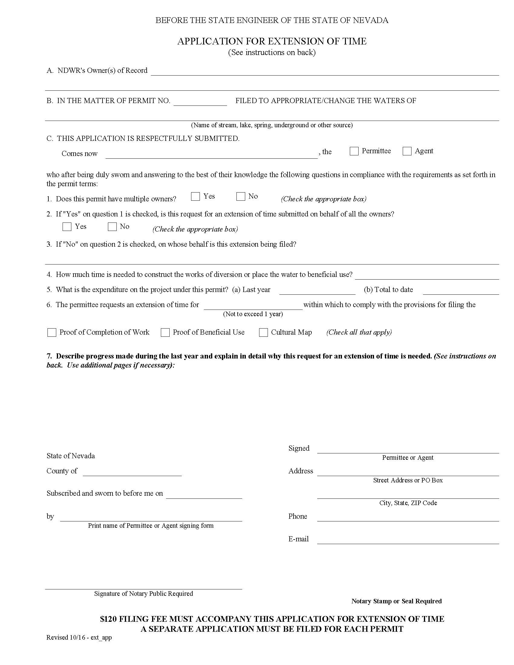
If the application is approved, the State Engineer will issue a permit to appropriate, with time periods set for completing diversion works (by statute, no more than five years) and for proving beneficial use (by statute, generally no more than ten years).[54] Extensions of time, of one year’s duration, for completing works or proving beneficial use can be obtained so long as the applicant is proceeding in good faith and with reasonable diligence.[55] Multiple extensions of time are fairly common.
If the applicant fails to proceed to prove up the right with reasonable diligence, the application may be canceled by the State Engineer[56]. Once beneficial use is demonstrated to the satisfaction of the State Engineer, the applicant receives a “certificate” establishing the water right to the extent of the proven beneficial use.[57] The “certificated” right is then vested. Loss of the water right is then governed by the forfeiture and abandonment provisions discussed in Section IV.
Changes in the point of diversion, manner and place of use require application to the State Engineer and may be subject to public notice and protest. This requirement applies to “decreed” rights as well as “permitted” rights.[58]
E. New Mexico
New Mexico follows the prior appropriation doctrine for both surface water and groundwater. N.M. Const., Art. XVI, Sec. 2. A water user obtains the right to use the water, but never acquires the water itself, which is owned by the state.[59] The State Engineer conjunctively manages the resource to ensure that the rights of river users are not impaired by groundwater pumping. The New Mexico Supreme Court in City of Albuquerque v. Reynolds, 71 N.M. 428, 379 P.2d 73, 80-81 (1962), recognized the State Engineer’s authority to place conditions on permits for groundwater pumping that would protect the river affected by the pumping. Today, since surface water is considered overappropriated, protection of the rivers becomes important and drives many of the water transactions. Surface rights, typically from farms, must be acquired to support proposed new permits for wells and groundwater pumping.
Although New Mexico follows the first-in-time, first-in-right policy, priority calls still are relatively rare. The State Engineer’s office, which administers water rights, recognizes water rights perfected prior to 1907, when the Territory of New Mexico adopted its first Water Code affecting surface rights. NMSA § 72-9-1. Before that time, water rights were acquired through beneficial use. Afterward, a permit was required to begin putting surface water to beneficial use. By contrast, portions of the Water Code regulating groundwater were not adopted until 1931, and the State Engineer does not take jurisdiction over groundwater until he “declares” an underground basin. State ex rel. Reynolds v. Mendenhall, 68 N.M. 467, 362 P.2d 998 (1961). Some underground basins were declared in the 1930s, and declared basins covered most areas of the state by the 1980s.
Under current New Mexico law, permits for either a surface or underground right require applications for a permit. NMSA 1978 § 72-5-1 and 72-12-3, respectively. The applications must be published in a local newspaper for three weeks, and anyone who thinks the appropriation would impair his water right may protest. In addition to impairment and whether unappropriated water is available, the State Engineer also considers whether the application will be contrary to conservation of water within the state, and will impair the public welfare of the state. These criteria also generally apply to applications to transfer or change the point of diversion, purpose or place of use, as discussed below. The impairment criteria are evaluated on a case-by-case basis by the State Engineer,[60] and the other two criteria (conservation and public welfare) have not been defined in regulations or case law.
If the application to appropriate water (now almost always groundwater) is approved, the applicant must meet conditions that typically include a time limit to construct the well and put the water to beneficial use. Extensions of time for a maximum of three years[61] are common, but recently the State Engineer has indicated less willingness to approve the extensions automatically, especially if the permit holder has asked for multiple extensions.
On rare occasions, the State Engineer will cancel a permit if the water user fails to put the water to beneficial use. After the water has been put to beneficial use, the permit holder can apply for a license certifying beneficial use,[62] but these also are relatively rare. Water rights can be forfeited or abandoned through non-use, as discussed below.
F. Oregon[63]
Prior to the enactment of Oregon’s (surface) water code in 1909, the state recognized both riparian and appropriative rights. Riparian rights can now be claimed only to the extent that riparian owners were using water beneficially before (or immediately after) passage of the 1909 Water Code.[64] This hybrid system is known as the “Oregon doctrine.”
There are three fundamental principles in Oregon water law: beneficial use, priority, and appurtenances. Beneficial use “is the basis, measure, and the limit of all rights to the use of water in this state.” [65] That is, a right to divert and use water is valid only to the extent that the water is applied to a beneficial use for a specified purpose. A wide variety of uses are considered beneficial.[66] However, uses may be limited if the proposed source has been withdrawn from further appropriation or has been classified by the OWRD for more limited uses or quantities of use.[67] Basin plans may further limit or prioritize uses.[68] Oregon law has no explicit “use preference” except that in times of shortage, domestic purposes have first preference all other uses and agricultural purposes have preference over manufacturing.[69]
Priority in Oregon is “first in time, first in right.” The person who holds the right with the earliest priority date receives all the available water, up to the total amount of his right. (The priority date is generally the time the water was first put to beneficial use, or the date of the permit application for that use.) Whatever available water is still left in the stream goes to satisfy the next oldest, or senior, right, and so on down the line until either all the water rights of use are satisfied in order of priority, or all the available water is used.
The third basic principle of Oregon water law is that the water attaches to the land after it is perfected and the development completed on that land. Thus, a water right certificate is said to be appurtenant to a particular piece of property.[70] Statutes require disclosure of the existence of water right certificates, or transfer approval orders by anyone selling land that includes any surface water irrigation rights, as well as notification to the OWRD.[71] Since the water right is appurtenant to the land, the seller must specifically reserve the water rights if the seller intends to keep them.[72] Appurtenance also requires that water cannot be taken and applied to other land without application for a transfer.
According to statute, “all water within the state from all sources of water supply belongs to the public.” ORS 537.110. As outlined above, Oregon recognizes the prior appropriation doctrine and applies its unique form of the doctrine to precode claims in adjudications, and as statutorily enacted, to post code claims.
Water rights of use acquired before the permit system was in place, are ‘vested rights’ and are confirmed though the adjudication process. Claims for pre-1909 surface rights were required to be registered with the state by December 31, 1992. Claims not registered were forfeited. Claims for groundwater put to beneficial use prior to August 2, 1955 (the date of enactment of groundwater codes) are recognized if they were registered within three years after the adoption of the code.[73] Oregon statutes provide the mechanism for sorting out pre-Code rights.[74] The OWRD is in process of conducting adjudications of streams to issue final decrees that will confirm the existence of pre-1909 rights their priority in relation to other rights.[75] Until the adjudication process is completed, OWRD can process requests to change place of use, type of use or diversion of registered pre-1909 water rights who have unadjudicated claims without affecting basin adjudications already underway.[76]
With certain exceptions[77], all rights to use surface water since 1909 are acquired through the state’s permit system. Groundwater rights of use are similarly acquired through a permit system in place since 1955, also with certain exceptions.[78] The groundwater system is integrated with the surface water system where a hydrologic connection exists;[79] however there must be substantial evidence of a direct and measurable hydrologic connection between surface and groundwater to support conjunctive management.[80] Although most exempt uses carry a valid right of use equivalent to certificated water rights, proof of a priority date and continuous beneficial use may be difficult without the documentation provided by a paper right.[81] Water rights in Oregon are treated as perpetual so long as they are exercised continuously.[82]
Valid, perfected water rights are recognized by a water right certificate issued by the OWRD. Certificates are issued pursuant to adjudications or after final proof survey confirming to the OWRD the application of the permitted waters to beneficial use.
OWRD administers water law under policy direction from the Water Resources Commission. Water law is codified in chapters 536 – 543 of the Oregon Revised Statutes cover both groundwater and surface waters. Oregon requires permits for all water appropriations.
Oregon’s water law has seen significant changes in interpretation effecting water rights over the past fifteen years as the competition for the resource increased.
II: Identifying the Water Rights
The first step is obviously to identify what water rights are to be conveyed as part of the transaction. This may sometimes not be a straight forward task. Often the parties may not have been very clear in their contract, simply using general phrases such as “any and all water rights” or “all appurtenances” or even being silent on the issue. The due diligence lawyer will need to determine what the intent of the parties was with respect to what, if any, water rights are to be conveyed.
Oftentimes, the parties themselves will not know precisely what water rights are associated with the property, at least to the level required to prepare an adequate conveyancing description. Even if the parties purport to know what water rights are associated with the property, the due diligence investigations should confirm these beliefs. The means of determining what water rights are, in fact, appurtenant to the property varies from state to state.
A. Arizona
In Arizona, most surface water rights are evidenced with a certificate, permit or statement of claim. All of these records can be found at the DWR. Groundwater rights within the state’s AMAs are evidenced by certificates or permits. All wells in the state are or should be registered with the DWR. The main DWR office is in Phoenix, and each AMA also has an office. The files in the Phoenix office are supposed to be complete, but sometimes records can only be found at the AMA office. The DWR website[83] is a good starting point for searching for information on water rights in Arizona. Some of the forms are on the site, as well as an online bookstore catalog, descriptions of the AMAs, and the Active Management Plans. Another useful resource are the maps the DWR produces on CD. Separate CDs (approximately $20 each) are produced for surface and groundwater rights in the state. After entering a legal description using section, township and range, the CD produces a map with file numbers for all the ground or surface water rights around the land described.
In Arizona, it is important to confirm that the water right can be used for the intended purpose. Groundwater rights are heavily regulated (as detailed below), and some rights can be used only for particular purposes. For example, irrigation grandfathered groundwater rights can be conveyed only with that land,[84] but they may be extinguished, in some cases, to be used toward proving an assured water supply.[85]
B. California
Appropriative, riparian, and groundwater rights each emerge from unique geographical and physical characteristics, and as such, each holds a unique status in the law. Identifying these rights requires a basic legal understanding of how the rights are created by law, along with the appropriate investigation for each type of water right. In addition to these real property-based rights to water, there are also contract-based rights to water, such as the water delivered by the federal Central Valley Project or the California State Water Project. Identifying these contract-based rights can be done through a review of the seller’s files.
Appropriative Rights
As discussed above, an appropriative right is a real property right that allows one to take surface water, or water in subterranean streams flowing through known and definite channels and put it to a beneficial use. This right is not contingent upon ownership of the land through which the water flows, or even necessarily to which the water will be applied. The first place to start in identifying an appropriative right is the SWRCB. There, one can begin by looking at the SWRCB filings under the name of the seller, subsidiaries of the seller, part owners, predecessors in interest, etc for applications, permits, or licenses which have been filed or granted to appropriate water. One should also look at the SWRCB maps to determine if there are any recorded water diversions, for applications, permits, or licenses, associated with or near the property. If relevant applications, permits, or licenses are located, one can look at the applications, permits, or licenses themselves to find if the place of use identified corresponds with the location of the property.[86] If the water right has matured into a license, proof of the license can also be found in the records of the county in which the diversion occurs.[87]
In the context of a real estate transaction, an appropriative right might accompany the parcel being purchased, or it may be held by a mutual water company, irrigation district, or other type of district, that serves the parcel in question. Therefore, the next step in searching for an appropriative right is to find out if there is a mutual water company, irrigation district, or other special district which serves water to the area. The amount of water available and the purposes for which the water may be used will be determined by the water service provider based on legal and physical restrictions of that service provider.
Because water rights established prior to 1914 are not governed by the SWRCB, the SWRCB may not have anything in its files to signal the existence of a pre-1914 right. One may, however, sometimes find recordings of these rights at the county recorder’s office or in other historical references. Prior to the permitting system administered by the SWRCB, an appropriator would provide notice of the proposed diversion by posting or publishing actual notices or by filing for the right in the county recorder’s office. The existence of a permit, license, application, or pre-1914 right, however, does not end the inquiry as to the existence of a legally valid water right. As explained above, all water rights in California must be put to reasonable and beneficial use, and if not, can be forfeited under law. See section IV, infra. Additionally, the courts may have adjudicated the water right as well.
Riparian Rights
As discussed above, a riparian right gives the owner of land contiguous to a natural watercourse a right to beneficially put the water to use on the riparian land. The first step in discovering the existence of a riparian right is to physically investigate the property for signs of a natural water source running through or adjacent to the property.[88] The riparian water source may be ephemeral in nature, so it is important to look not only for water, but other indications of the temporary existence of water such as a gully or dry streambed. Even if a riparian water source is present, the riparian rights to that property may have been severed from the property. If the property was subdivided at some point in time, the riparian right attaches only to the smallest parcel still contiguous to the water source.[89] Changes in the riparian right are almost never reflected in the deed.
Additionally, one should check filings with the SWRCB because the SWRCB accepts riparian right filings which are often made so as to be able to prove up a riparian right later in time. If a riparian right is found, it is not necessary to do the same follow-up investigation as required of appropriative rights because a riparian right is not based upon use, and hence it is not lost by disuse. However, the best way to know if a riparian right still exists is to obtain a title opinion from a competent water counsel.
Groundwater Rights
Also as discussed above, a property owner whose land overlies a groundwater basin has a right to withdraw water from the basin, correlative with other property owners whose property also overlies the basin. A groundwater right may cause special concern because not only is it unnecessary to file notice with the SWRCB, the availability of water for extraction is not readily apparent if there are no physical signs of groundwater, such as wells or springs. Currently, the Department of Water Resources is preparing a map of California’s groundwater basins. When completed, a person may be able to start their research with that database, checking the location of their property against the map. However, such a map will likely not be detailed enough to determine the actual presence of groundwater.
Until such time as detailed maps exist, if it is suspected that the property overlies a groundwater basin, one should hire a hydrologist to test for groundwater. Additionally, investigation into whether a water master has been appointed by the court may reveal the existence of an underlying groundwater basin. If it is determined that the property does in fact overlie a groundwater basin, one must do further research to determine if the basin has ever been adjudicated. The Department of Water Resources keeps tabs on such adjudicated basins. The presence of such an adjudicated basin can be good if you find the property holds an adjudicated right. Absent such a right, however, the acquisition of a new right may be challenging, if not impossible. Additionally, a call to a local water district to find out the status of the basin may uncover whether or not there has been an adjudication of rights to the basin.
Additional Investigative Tools
One cannot underestimate the value of a visual inspection of the property. The existence of pipelines, ditches, or wells or the presence of a surface stream on the property can alert one to the existence of a water right which should be investigated. Additionally, using a historical research firm to investigate the history of the property or prior owners of the property may help discover whether water rights are associated with the property, and if so, their status. This research covers newspapers, construction documents, and other sources which are always left out of the standard title search. Finally, water right engineers are another source for the investigation of water rights. Hiring the right expert can be very important in identifying the water right.
C. Colorado
In Colorado, the State Engineer maintains a computer listing of all decreed water rights in the state known as the Water Rights Report and commonly referred to as the “tabulation.”[90] The tabulation comes in three versions — one sorted alphabetically by the name of the decreed structure, one sorted by order of priority within a stream system, and one sorted by the section, township and range of the decreed structure’s point of diversion. A review of USGS maps of the area often reveal the presence of reservoirs or ditches. Conversations with the manager of the property and local water officials normally will reveal additional useful information. Finally, the field investigations undertaken as part of other due diligence investigations discussed below will help identify the ponds or ditches, irrigated fields, wells, or other evidence of the existence of water rights.
Once the rights are identified, copies of the relevant decrees, well permits and other evidence of the water rights involved should be obtained and reviewed. Most of these documents can be found at the State Engineer’s Record Section in Denver. Unfortunately, most of these documents are not yet available on line. However, the State Engineer maintains an extensive web site that includes stream flow records, rules and regulations, policies, diversion records and other material helpful in due diligence investigations. The web site is located at www.water.state.co.us.
D. Nevada
In addition to determining what the parties’ intend with respect to water rights appurtenant to the property in question, the due diligence team will need to ascertain whether additional or different water rights are needed to serve the property and project in question.
In Nevada, water may be available from a local water purveyor or governmental authority. However, even within the service territory of an existing water purveyor, a developer may be required to obtain water rights and dedicate these to the purveyor or local government in order to obtain water service. In Washoe County, for example, satisfaction of these requirements is a condition for obtaining a building permit or subdivision approval for new developments. The requirements for obtaining service commitments varies widely throughout the state. The water rights to be dedicated need not be appurtenant to the property in question, but restrictions as to the appropriate type of water right will apply. Usually it is necessary to obtain and dedicate a larger volume of water than will actually be needed to serve the property, as a hedge against drought conditions. The water purveyor or governmental entity will undertake a due diligence review before accepting the right.
A water right is not required for a domestic well that draws no more than 1,800 gallons per day.[91] Such a well may not be constructed within the service territory of a water purveyor, and, in the event a service territory expands to encompass property served by domestic wells, there are statutory provisions encouraging, and in some cases requiring, the abandonment of such wells.[92]
E. New Mexico
In New Mexico, some water rights have been adjudicated, and a new automated system for identifying water rights is called “W.A.T.E.R.S.”[93] However, not all rights are even permitted. Surface water rights developed before 1907 do not need a permit, nor do groundwater rights developed before the State Engineer declared and took jurisdiction over the particular groundwater basin where the wells are located. Most prudent water rights owners, however, have filed “declarations” of their surface or groundwater rights with the State Engineer’s office, which is the first stop for learning about the water rights. The files in the main State Engineer office in Santa Fe are supposed to be duplicates of files in the district offices around the state,[94] but that is not always the case. Sometimes a check in both the Santa Fe and District office is warranted. Under New Mexico law, the declaration is prima facie proof of the validity of the water right,[95] but the State Engineer often challenges a declaration based on many of the same sources outlined in the due diligence checklist. The due diligence, therefore, should only begin with the permit or declaration, not end there.
F. Oregon
Most water use in Oregon is documented by a decree tabulation, statement of claim, permit, or certificate kept with the OWRD. Unfortunately, the large remainder are not documented and fall generally into the following categories: (1) Exempt uses; (2) Federal reserved rights; (3) Wild and Scenic River flows; and (4) Reservations for future appropriation which are not recorded. If the transaction considered might fall within state exemptions, the investigator must also consider whether the local land use planning agency (usually county or city) has its own limiting restrictions.
To begin the identification process of documented water uses, the investigator should start with the OWRD’s website[96] by entering the appropriate section, township, and range data. The website should produce a “plat card” for the appropriate section with identifying numbers entered by quarter/quarter sections. Since OWRD indexes its files by the application number, research from the plat card may include determining the permit and certificate numbers both of which will be different than the application number. The website may also include a copy of the pertinent right. However, associated file documents are not included on the website at this time requiring the investigator to travel to the state files in Salem or to the regional watermaster’s office.
While the state and regional files are intended to be exact duplicates, this is rarely the case. A wise investigator should start by retrieving a complete copy of the pertinent State file(s). Obtaining copies of these files, usually requires the legal practitioner to earlier submit a Public Records Request. It is advised to ask for all related files as OWRD often maintains several files for the same water use. The regional files may also yield additional information. Important documents to retrieve from the file include copies of easements and contracts.
Because ownership of the paper right is determined by its property appurtenancy, the name on the paper right[97] will not likely be the name of the appurtenant land owner but will name the initial applicant for the resulting water use. Therefore, the investigator may need to review the county records to first determine land ownership. This step is often a good idea to make determinations of existing easements. Often, a title company may be used for this purpose.
G. Conclusion
Once the water rights to be conveyed have been identified, a second question should be raised. Are the water rights adequate for the purchaser’s intended purposes? The amount, reliability, transferability and other attributes will be determined as part of the ongoing due diligence investigations described below. However, the due diligence lawyer needs to understand what the client’s intended use of the property is, so that a determination can be made whether the water rights will be adequate to meet the client’s needs. If the existing water use is to be continued, this is normally fairly easy to determine. However, if the client desires to make a new use of the water — e.g. converting farmland into a residential development — the due diligence lawyer will need to help the client determine exactly how much water the new land uses will require. For instance what are the average and peaking water demands of a residential development, what water dedication requirements will local service providers or authorities require, what amount will industrial uses require?
If the buyer is a conservation entity such as a land trust, the due diligence lawyer will also need to evaluate whether the water rights are adequate to protect the conservation values sought to be protected. For example, if a conservation value is a wetland or irrigated meadow for waterfowl habitat, are the water rights in place that are required to maintain such values? This may require additional scientific due diligence regarding the amount and timing of water required for these specific land uses.
III. Water Right Ownership and Title Examination
A. Arizona
In Arizona, there are several different types of surface and groundwater rights, with several different types of proof of the rights. In general, except for decreed rights, the DWR has ownership and assignment records. However, for surface rights in particular, due diligence should include a title search of the land associated with the water right. Title to groundwater rights can be held separately from the land, and title can be searched through DWR records only.
Arizona state law provides for four types of surface water rights.[98] All types of surface water rights should be conveyed by deed, not a bill of sale.[99] Notice of the conveyance should be filed with DWR using the DWR’s forms, except for decreed rights.[100] The first type of a surface water right is one acquired before June 12, 1919, which is evidenced with a statement of claim filed with DWR.[101] The second type of surface right is one acquired after June 12, 1919, pursuant to an application and permit to appropriate water. DWR issues a Certificate of Water Right as evidence of these rights.[102]
The third type of surface water right is a stockpond right. DWR evidences these rights with a Registration of Stockpond filed with DWR and, on rare occasions, with a Certificate of Stockpond Right.[103] The fourth type of surface water right is a decreed right. These rights have been adjudicated and confirmed by a court.[104] No readily accessible repository exists for these rights, although DWR often has information regarding decreed rights.
Groundwater in Arizona is heavily regulated, even though the state generally follows the “reasonable use” doctrine[105] instead of the prior appropriation doctrine for groundwater. The Arizona statutes designate AMAs in areas where groundwater aquifers are at risk of being rapidly depleted and provide stringent regulations in those areas.[106] The AMAs include the Phoenix AMA, the Pinal AMA, the Tucson AMA, the Prescott AMA, and the Santa Cruz AMA.[107] Elsewhere in the state, areas have been designated as irrigation non-expansion areas.[108] In these areas, groundwater use is not as heavily regulated as in the AMAs, but new irrigated acreage cannot be developed.[109]
Within the AMAs, all the types of water rights should be conveyed by deed,[110] and the Notice of Conveyance must be filed with the DWR.[111] The first type of groundwater right is an irrigation grandfathered groundwater right, which allows the right holder to withdraw and use groundwater for irrigation purposes on a specific piece of property.[112] The DWR issues a certificate of irrigation grandfathered groundwater right as evidence of the right. Irrigation rights are appurtenant to the land that was historically irrigated and can be conveyed only with that land.[113] In some circumstances, irrigation rights can be retired and converted into Type I non-irrigation rights (discussed below) or can be extinguished to obtain credits that can be used in proving an assured water supply.[114]
Type I non-irrigation grandfathered groundwater rights originate from retired irrigation acreage. [115] The DWR issues a certificate of Type 1 non-irrigation grandfathered groundwater right for a specific amount of water. The right is appurtenant to the historically irrigated acres, but it can only be used for non-irrigation purposes.[116] In limited circumstances, the water withdrawn pursuant to a Type 1 right may be used on land other than the appurtenant acreage.[117] Type 1 rights sometimes can be extinguished to obtain credits that can be used for proving an assured water supply.[118]
The use of Type 2 non-irrigation grandfathered groundwater rights is less restricted than other groundwater rights in an AMA. The DWR issues a certificate of Type 2 non-irrigation grandfathered groundwater right for a specific amount of water for non-irrigation purposes. Type 2 rights are freely transferable within the AMA subject only to well spacing requirements. The right can be leased in whole or in part.[119] In some circumstances, Type 2 rights may be extinguished to obtain credits that can be used to prove an assured water supply.[120]
Within an AMA, it also may be possible to obtain permits to withdraw and use groundwater for the following purposes:[121] general industrial use, dewatering, mining, poor quality groundwater use, temporary electrical generation or dewatering, drainage, and hydrologic testing. These permits generally are of a short (less than 50 years) duration and are, in most cases, transferable.
The final type of groundwater right in an AMA is a withdrawal from an exempt well. An exempt well is a well with a maximum pump capacity of 35 gallons per minute.[122] Exempt wells drilled (or in progress) before April 28, 1983, can be used to divert up to 56 acre feet per year for non-irrigation purposes.[123] Exempt wells drilled after April 28, 1983, can be used to withdraw up to 10 acre feet per year for domestic and stock watering purposes.[124]
B. California
Issues associated with water right ownership and title examination go hand-in-hand with those discussed in identifying the water rights (see section III, supra). The very act of identifying a right may address all or most questions of title examination and ownership, such as when a title opinion is performed to determine the existence of a riparian right. This work is painstakingly detailed and full of traps for the untrained and should only be attempted by a competent water counsel with the help of an experienced title investigator.
Where water has been appropriated for use upon certain land which cannot be used advantageously without it, the water right is an adjunct to the land and passes in a conveyance of the land as appurtenant thereto, unless otherwise provided.[125] Of course, the appropriative right may be sold as real property, separate from the underlying land, subject to the statute of frauds.[126] But even after such a sale, the normal restrictions on change of place of use and purpose of use would still apply. (See section VII, infra).
In terms of title insurance, while California title insurers will insure easements relating to the conveyance of water across property (for example, providing insurance that the dominant tenement does hold the right to convey water through a pipe or ditch across the property of the subservient tenement), title insurance for the underlying water right itself is rare if not non-existent.
C. Colorado
In Colorado most water rights are evidenced by judicial decrees of the Water Courts (one of seven district courts throughout the state whose primary docket is water related matters), rather than by administrative permits.[127] The State Engineer maintains a tabulation of such water in a computerized data base.[128] Groundwater rights both within and outside of designated groundwater districts are normally evidenced by well permits issue by the State Engineer, copies of which are available from his office and searchable in a computerized data base.[129]
Title insurance cannot be obtained in Colorado on water rights. Water rights are normally transferred by deeds recorded in the local real property records.[130] Water rights represented by stock in mutual ditch and reservoir companies are normally evidenced by share certificates issued by such ditch companies, in which case the company’s stock transfer records must be examined and any bylaw restrictions observed. Some water rights are evidenced by allocation contracts with water conservancy districts, which may or may not be recorded, which case the district’s records must be examined.
For valuable water rights, it is common to conduct a stand-up title examination in the real property records of the county in which the water right was historically used. This consists of a manual search of the grantor/grantee records to develop a chain of title from the person to whom the water right was initially decreed, to the present owner. For water rights decreed in the 1800’s — which in Colorado is the norm for water rights of any decent seniority — it is common for the title search to be limited to 20 or 30 years back from the current apparent owner to avoid the considerable cost of developing a complete chain of title.
Unfortunately, such title searches are often not conclusive because Colorado courts have held that water rights can be conveyed under such vague terms as “all water rights appurtenant to the property” or even a general appurtenance clause. Whether specific water rights are conveyed by such general language is dependent on the intent of the parties based on all the facts and circumstances surrounding the transaction.[131] Thus, where one or more instruments in the apparent chain of title do not specifically describe the water rights in question, but do contain such appurtenance language, the title examiner must make assumptions regarding the intent of the parties.
Partly because of these uncertainties, due diligence investigations also usually involve discussions with the local water commissioner (the state official in charge of administration of water rights on the local level) regarding the historic use of the water rights. A water rights engineer is often also hired to perform field verification of the place and extent of use — e.g. has the water right been used solely on the property of the owner claiming title. Such field investigations sometimes reveal claims of ownership not reflected in the record title.
D. Nevada
Although Nevada has made considerable progress in simplifying and clarifying management of title records for water rights in the last five years, the task of verifying legal title to a water right can be a daunting one. Title insurance for water rights is not available in Nevada and there is no easy substitute for physical inspection of the appropriate public records. Fortunately, there are specialists in the state willing to take on this task and who can often accomplish title research cost-effectively. The Division of Water Resources is making good progress in compiling a current title data base, which is available on-line at the Division’s website. http://ndwr.state.nv.us While this is at least a good starting place to review current record title, official records are now maintained at the county recorder’s offices.
Water rights in Nevada, whether decreed, permitted, or certificated, are treated as real property[132] and conveyed by deed.[133] A deed for real property is presumed to transfer any appurtenant water rights, unless the water rights are specifically exempted from the conveyance.[134]
Until 1995, official records of conveyances of water rights were maintained by the State Engineer’s office.[135] At the same time, official records of transfers of other real property were (and are) maintained by the appropriate county recorders.[136] This dual records system led to considerable disarray in property records, particularly since water rights were commonly transferred with real property in a single instrument, and the requirement for recordation with the State Engineer was often neglected. In 1995 the law was changed to make the county recorder the appropriate place for recordation of water rights conveyances.[137] If the county where the water is diverted is different from the county where the water is used, recording in both counties is required.[138] A deed which is not recorded in compliance with NRS 533.382 is void as against a bona fide subsequent purchaser who first records in compliance with that statute.[139]
Title records are still maintained by the State Engineer, however, and the transferee of a water right is required to file a record of conveyance with the State Engineer together with an abstract of title.[140] This requirement must be met to enable the State Engineer to provide appropriate notice of pending expiration of time for completion of works or proof of beneficial use or other necessary notices.
The implications of the prior dual records system for title research are self evident. Depending on the date of the conveyance, it may be necessary to check records both at the State Engineer’s office and county recorder’s offices back to the original decree or application to verify a chain of title. In addition, in most cases, the conveyancing documents should be examined directly to identify reservations or inconsistencies in the place of use. County recorders in Nevada maintain both grantee and grantor indices, and both should be checked. It is not uncommon to find incomplete transfer histories and confusing deeds. For example, “appurtenant” agricultural water rights may have been transferred with a subdivided agricultural parcel without specification of how such rights should be subdivided. Clarification of the extent of the water right conveyed may require a historic review to determine what portion of the subdivided parcel was actually irrigated.
It should be noted that several of the most significant decrees in Nevada are federal decrees administered by the federal court system through a water master. Records of conveyances of decreed rights under the federal decrees are also maintained by the appropriate water master and these records should be reviewed in addition to county and state records. It should also be noted that certain water rights in Nevada are maintained by “ditch companies,” private companies that still manage the distribution of water along a ditch system, and evidence the right to receive water through shares of stock in the company. These “ditch rights” are not the equivalent of water rights.
As real property, water rights in Nevada may be encumbered – a security interest in water rights is usually evidenced by a deed of trust recorded with the county recorder. A notice of pledge should also be filed with the State Engineer. Complete title research for adequate due diligence must therefore include a search for such encumbrances.
E. New Mexico
In New Mexico, both surface and groundwater rights are property rights, and they may be conveyed by deed separately, or as part of a conveyance of property. However, there is no general requirement that water rights be declared or permitted, and many irrigation rights have not been documented in the State Engineer’s office or in county property records. Thus, title to most water rights must be traced through the title to the appurtenant land. Water rights are appurtenant to irrigated land, but they are not appurtenant to land if they are used for other purposes.[141] For these non-irrigation rights, which are the exception in New Mexico, the title should be traced through a deed referencing the permit, if possible.
State Engineer records seldom have a complete record of ownership of water rights, because sellers and buyers were not required to file change of ownership forms with the State Engineer until 1991.[142] Title insurance is not available for water rights in New Mexico, so the due diligence inquiry usually requires obtaining a search and report from a title company. Title companies generally will search the grantor-grantee index for deeds for the underlying property, and the lawyer can review the deeds to ensure that the water rights were not conveyed away to a third party or reserved to the grantor. Many deeds include the phrase “and all appurtenant water rights,” which generally is sufficient to convey irrigation water rights, but it may lead to ambiguity if the water rights have been split up over time.
In the case of surface rights, it is best to trace the land title back to 1907, when New Mexico adopted its surface water code and new surface rights had to be obtained by permit. If that is impractical, generally looking 30-40 years back will provide enough of a record to examine whether water rights were encumbered by a mortgage or stripped off the land and separately deeded to another party. For groundwater rights, the best review would examine the chain of title from the time the well was first drilled. If it is a very old well, and began production before its particular groundwater basin was declared, examination of the title from the time of the basin declaration probably will be adequate to confirm that the seller has good title. The State Engineer declared the various underground basins at different times, so the “start date” for title examination in these cases will also vary.
F. Oregon
Once the water rights are determined and the initial pertinent materials collected, the investigator can identify water rights of use by type. Oregon types include those recognized by source: (1) surface, (2) groundwater, (3) storage, and (4) instream. Some lands may include water uses from several sources and are supplementary to the primary source that is likely to be the surface source though not always.
Surface Use
Surface water uses are limited in Oregon by basin rules and by the available supply as determined by the OWRD. If water is not available for the new use at least 80% of the time, the use will not be permitted.
Since the adoption of the respective Water Codes, Oregon has a three step process to obtain water rights, starting with a permit application submitted to the OWRD.[143] The permit allows the recipient to develop the water use under specified conditions and limitations. The permit holder must then proceed with due diligence to perfect the right within the time limit set by the permit, constructing the system and putting the water to beneficial use. The time period for completing construction is five years and may be extended for good cause.[144] In completing a thorough investigation of unperfected rights, it is necessary to ascertain whether the permittee timely completed all necessary steps otherwise the permitted use may be at risk for later limitation or cancellation. Oregon’s former policy for granting liberal extensions is currently under question, and new rules are being adopted to make extensions more difficult to obtain.
After the completion of construction and the user has applied the water to intended beneficial use, the water use must be “surveyed” by Certified Water Rights Examiner.[145] This survey must show the point of diversion, the amount of water being used, and a description and map of the land to which it is being applied.[146] If the OWRD finds the survey of water use in compliance with the terms of the permit, OWRD will issue a water rights certificate[147] which represents a perfected water right with a priority date of the time the original permit application was filed.”[148]
Groundwater Use
In 1955 the state enacted the groundwater code that governs all use of groundwater.[149] In order to obtain a groundwater use, the applicant must follow the same steps outlined above for a surface water right of use. Oregon has limited groundwater permitting and withdrawals in certain areas of the state where hydrological information proved aquifer decline. These areas are defined by rulemaking so that identification of groundwater uses will include reviewing administrative rules (including basin and groundwater area rules) to determine if the groundwater use will fall within the boundaries of a limited or critical area where allocations are limited. OWRD personnel are also good sources in making these identifications.
Storage Use
As to storage, a permit or exemption is required in order to build, maintain, or use any pond or reservoir, and there are additional regulations for these uses.[150] Oregon also permits aquifer storage and recovery.[151] As a policy matter, Oregon favors water storage.
To qualify for an exemption, smaller reservoirs must have been built before 1995 and a notice of exemption filed before January 31, 1997. A water use for a pond or reservoir may have advantages over an exemption, however, such as a set priority date and amount of storage allowed. Stored water permits allow storage of streamflow that is surplus to the needs of existing rights. This is considered a primary storage permit. In addition, in order to use water from a pond or reservoir a secondary permit may be required. A stored water right usually does not have to release stored water to satisfy the unmet demand of a senior natural flow right. However, there must be a means to allow the passage of the natural flow of the stream through or around the reservoir.
Some water storage requires the applicant to provide a contract for use from the storage as part of the application and continued use of water. This requirement is most likely applied to United States Bureau of Reclamation facilities.
Instream Use
Oregon water law provides some special water rights. By statute, water can be held for instream use, defined as “a water right held in trust by the Water Resources Department for the benefit of the people of the State of Oregon to maintain water in-stream for public use.”[152] Obviously, this use is not within the definition of “prior appropriation.”
Except for instream uses, in Oregon ownership of a water right attaches to the appurtenant land where the water is used. Consequently, the water right is “owned” by the appurtenant landowner which may not be the same as the name which appears on the permit or certificate. The OWRD in Salem maintains records of all legally established water rights (incomplete rights under permits, undetermined claims through ground water registration or vested right statements, or completed rights). The regional watermaster also has this information. A due diligence lawyer should be aware that there is no requirement in Oregon to record water rights in the county deed records.
IV. Validity: Nonuse, Abandonment and Forfeiture
A. Arizona
As outlined above, there are many types of surface and groundwater rights in Arizona. Care should be taken that the water rights have been properly certificated or permitted, and that the appropriate claims have been filed in the general adjudications currently pending that cover most of the State.[1] All of these claims should be assigned to the purchaser, and notice of the conveyance should be filed with the DWR. Adjudication records should also be reviewed to determine if the DWR has investigated and reported on the claim, and whether any objections have been filed with respect to the claim.[2]
A historical review can reveal whether periods of non-use may subject the surface water right to claims that the right has been forfeited or abandoned. Forfeiture is a statutory mechanism that may result in loss of certain surface water rights and can be triggered by failing to use water for five years.[3] Abandonment requires the intent to abandon the water right, which can be evidenced by a party’s declaration or inferred from his acts. Gould v. Maricopa Canal Co., 8 Ariz. 429, 76 P. 589 (1904); San Carlos Apache Tribe v. Superior Court, 193 Ariz. 195, 972 P.2d 179 (1999) (discussing abandonment and forfeiture).
The due diligence for groundwater rights in Arizona in similar to that for surface water rights. One consideration is whether the right is properly permitted or certificated, which can be determined by reviewing DWR records. Another factor is whether something has occurred to put the water right holder in violation (such as water use in excess of the permitted amount) or otherwise impair the right (such as extinguishment). DWR records also can reveal these problems, as can the annual withdrawal and use reports that are required to be filed with DWR. If the groundwater right is in an AMA, the buyer should determine what, if any, conservation requirements apply to the right or the proposed use. Conservation requirements are set forth in the management plans for each AMA and are available from DWR, including from its website.
Whether the groundwater right is inside or outside of an AMA, other considerations also are important. The buyer should determine if the well is properly registered with DWR.[4] The physical availability of groundwater should be evaluated. If groundwater will be withdrawn from an existing well, the well and the aquifer should be evaluated to ensure they are physically capable of delivering the quantity and quality of water supply expected.
B. California
California water rights may be lost in one of four ways: statutory forfeiture, abandonment, prescription, and estoppel. Not all California water rights are subject to loss under all of these theories. One cannot, for example, forfeit or abandon riparian or overlying rights because the rights are part and parcel of the land. These rights are not acquired by use and therefore cannot be lost by non-use.[5] The doctrines of estoppel and prescription are quite complex and, for the most part, beyond the scope of this article. Consequently, the following discussion is limited to an examination of the principles of forfeiture and abandonment applicable to appropriative water rights.
Abandonment
One abandons an appropriative right by failing to use water or by yielding possessing of the water without any present intent to revive the right to use the water.[6] The non-use and intent to abandon must be concurrent; mere non-use is, at best, rebuttable evidence of an intent to abandon.[7] The period of non-use is not significant because abandonment occurs immediately at the concurrence of the requisite act (or failure to act) and intent.[8] Despite this temporal certainty, however, abandonment claims tend to be rare because the proponent of abandonment carries the burden of affirmatively proving intent. The burden of proof should counsel a proponent of abandonment to be cautions about relying on the rebuttable inference of non-use and intent.[9] In all cases, abandonment is a question of fact to be determined by the conduct of the parties.[10]
Forfeiture
The California Water Code currently provides that water held under a license or permit reverts to the public if the appropriator fails to apply the water to beneficial use for a period of five years.[11] Although the Code provides that a right ceases upon failure to apply water to a useful or beneficial purpose, it appears that the right is not officially forfeited, and the water considered available for appropriation, until the SWRCB issues a formal finding after notice to the permittee and, if the permittee requests, a hearing.[12] An appropriative right may be forfeited in whole or in part.[13] The party alleging forfeiture has the burden of proving non-use for the statutory period.[14] The principles applicable to appropriative rights held under permit or license apply with equal force to an appropriative right acquired prior to 1914.[15] However, it is not entirely clear whether the courts have exclusive jurisdiction to declare forfeiture of a pre-1914 right, or whether this jurisdiction might be shared with the SWRCB.[16]
Consistent with the general legal principle disfavoring forfeiture, both the courts and the SWRCB decline to find forfeiture where non-use is attributable to some event beyond the appropriator’s control.[17] Such events may include the diversion of water by another in circumstances not rising to prescription, lack of water due to drought, and destruction of diversion works by floods or other natural catastrophes.[18] The general rule is that non-use of water may be excused if water is not available under priority of right, or if a prudent person “following the dictates of good husbandry, either could not or should not reasonably be expected to use the water.”[19] Some issues remain with respect to the outer limits of control and prudence in this context. For example, it is not entirely clear whether a water right is forfeited if non-use is due to government restrictions or voluntary agreements. In this regard, the Water Code expressly provides that water is not forfeited if conservation efforts result in a reduction in use.[20]
The authorities do no clarify whether any five-year period of non-use will trigger forfeiture, or whether those five years must immediately precede the institution of an enforcement action. Past decisions of the California Supreme Court contain language implying that the five year period must immediately precede the forfeiture action.[21] However, these cases contain no pointed discussion of this issue, and it is difficult to ascertain whether the statements are merely dicta. It seems most likely, however, that California water policy requires a rule that water is forfeited for non-use during any five-year period. An alternative rule would allow water users to cure forfeiture simply by reinstating use, even after a substantial period of non-use. Such an outcome would contradict California’s emphasis on beneficial use and would be in derogation of other users’ reliance on the unused water.
Although both the SWRCB and the courts allow that a water right may be forfeited in part, they do not clarify how to calculate the forfeited amount if the period of non-use lasts beyond a single, discrete five-year period. This issue may depend in part on the antecedent issue of the timing of the forfeiture period.
C. Colorado
In Colorado, water rights can be lost by abandonment. Abandonment is defined as the “termination of a water right in whole or in part as a result of the intent of the owner thereof to discontinue permanently the use of all or part of the water available thereunder.”[22] Although the statutory definition requires an intent to abandon, case law provides that non-use of a water right for an unreasonable period can give rise to a rebuttal presumption of an intent to abandon, which presumption cannot be overcome simply by self-serving denials.[23]
There is no fixed time that constitutes a “unreasonable” period of non-use. Case law suggests that it may range from ten to twenty years. Circumstances that may overcome the presumption of an intent to abandon include circumstances beyond the water users control such as economic misfortunes, lack of water, and illness.[24]
Every ten years the Colorado State Engineer must prepare an abandonment list, in which are listed the water rights that the State Engineer believes have been abandoned. These lists are normally prepared by the local water commissioners and include water rights that have not shown any significant diversions for more than 10 years.[25] This list is published and notice sent to the last known owner of the water right. A proceeding is commenced in the local Water Court to decree the rights formally abandoned. Owners of the listed rights have an opportunity to intervene in such
judicial proceedings to assert the non-abandonment of their water rights.[26] The Court normally adopts the abandonment list for uncontested rights, and holds individual hearings on contested rights. Once the abandonment decree is formally entered and any appeals resolved, the listed rights are formally abandoned.[27]
Colorado also recognizes “conditional” water rights.[28] If a water right claimant has taken the “first step” towards making a valid appropriation of water, the claimant can come into Water Court and obtain a conditional water right that fixes the priority date and amount of the water right.[29] This allows a claimant to have the security of a fixed priority before spending the time and money required to construct all the necessary facilities. Once the project is completed and the water actually put to beneficial use, the claimant must come back to the Water Court to make the conditional water right absolute.[30]
Colorado statutes require owners of conditional water rights to come back to Water Court every six years to obtain a judicial finding that they have been “reasonably diligent” in moving their project to completion and putting the water to beneficial use. If an application for finding of reasonable diligence is not filed every six years, the conditional water right is deemed abandoned.[31]
Accordingly, due diligence in Colorado includes reviewing the abandonment lists with respect to absolute water rights and determining whether diligence findings have been timely made with respect to any conditional water rights. Moreover, as discussed more fully below, non-use of a portion of a water right to result in partial abandonment of the right, which is often revealed when the water right is sought to be judicially changed to a new use.
If the water right is represented by a well permit, it is also necessary to confirm that the well was completed and a statement of beneficial use filed prior to the expiration of the well permit. This will require a review of the State Engineer’s well permit records.[32] If the water right involves a reservoir, the due diligence lawyer should review the State Engineer’s dam safety records to insure that there are no storage restrictions placed on the reservoir or remedial work required.[33]
D. Nevada
The 1999 legislature considerably simplified Nevada’s law of forfeiture and abandonment of water rights. Nonetheless, complexities and inconsistencies still exist and different laws apply depending on whether surface or groundwater is the source of the right. The loss of a water right through abandonment requires an intention to relinquish the right. Abandonment requires a “union of act and intent.”[34] Forfeiture, by contrast, does not require intent, but works a loss of a water right by operation of law.
Surface Water
Prior to the changes enacted by the 1999 legislature, NRS 533.060(2) provided that upon failure to use water for the beneficial purposes for which the right exists for any five consecutive years, “the right to so use shall be deemed as having been abandoned,” and the owner or owners would “thereupon forfeit all water rights, easements, and privileges appurtenant thereto theretofore acquired…. and any qualified person may appropriate such water for beneficial use.” While the statute stated that the forfeiture section applied to all rights, including “vested rights,” it did not apply to water rights acquired before March 22, 1913, which are not regulated by the provisions of Chapter 533. The statute was not retroactive, and thus could not apply to work a forfeiture for non-use prior to the date of enactment.[35]
The 1999 legislature modified 533.060 by deleting subsection (2) which contained the forfeiture provision. A new subsection (2) was added, which provides that rights to surface water “shall not be deemed to be lost or otherwise forfeited for the failure to use the water therefrom for a beneficial purpose.” As a result of this provision, a surface water right cannot be lost be forfeiture. It is unclear at this point whether the law applies retroactively.[36] Case law has generally held that the loss of a water right is governed by the law in effect at the time the right was acquired.[37]
Prior to 1999, the law pertaining to abandonment of surface water developed primarily through case law. The amendment to section 533.060 enacted by the 1999 legislature clarified and restricted the conditions under which a surface water right could be abandoned, and set guidelines relating to a presumption of non-abandonment. Under the new law, agricultural water rights appurtenant to land converted to urban use, which have been dedicated to or acquired by a water purveyor, public utility or public body for municipal use are not subject to abandonment.[38]
Groundwater
The statutory provisions relating to the forfeiture of groundwater were not altered by the 1999 legislature and remain in effect. Failure for five successive years after April 15, 1967, to use beneficially all or any part of the underground water for the purpose for which the right is acquired or claimed, works a forfeiture of both undetermined rights and determined rights to the use of that water to the extent of the nonuse. By its terms, the law applies to all groundwater rights, including any that existed at the time of its enactment.[39]
Abandonment of groundwater rights is governed in part by NRS 534.090(4) which provides that the State Engineer may declare a water right abandoned.
E. New Mexico
The main concern in New Mexico is whether the water right has been used consistently since it was permitted or first used and vested. If they have not been used, they could be subject to forfeiture or abandonment. Before 1965, water rights could be forfeited for a period of nonuse of only 4 years.[40] In 1965, the statutes were changed to require that the State Engineer send out a notice of forfeiture and give the water rights owner a year to cure the non-use. Very few, if any, notices have even been sent out, so most inquiries for non-use for forfeiture focus on the pre-1965 period. A very long period of non-use, however, could result in a determination of abandonment, but abandonment is not defined in the statutes or even in New Mexico state law. Generally, a period of 18 or more years of non-use is considered to be enough to imply an intent to abandon, but no New Mexico case directly addresses this issue.
As the checklist demonstrates, there are many sources of information for checking the historic use of water rights. Not all sources will be available for every water right, and the local State Engineer’s office can be very helpful in guiding you to the sources available in that area. Generally, however, the current owner should be able to provide information documenting the use of the water rights, or direct the lawyer to other sources of information. Some contracts for sale provide such a requirement, including an obligation for the seller to produce information or create appropriate affidavits that document the use of the water rights.
To document the use of irrigation rights, for example, the Albuquerque office of the State Engineer will be looking at a minimum for the following items: the land was listed as irrigated on the 1917-18 map, was assessed as “cultivated” on the 1926 conservancy district map and reports, and can be seen as irrigated in aerial photos for every decade from the 1930s or 1940s forward. Affidavits also can be helpful, but only if they are specific in their descriptions of the land, the water use and the reason why the affiant has knowledge about the water use. Water rights that currently are in use should be inspected on the ground. Depending on the size of the deal, it may be prudent to retain a hydrologist or similar expert to assess the water features and suitability of the water rights for the stated purpose or, if transfer of the water rights is the goal, the suitability of the water rights for transfer.
F. Oregon
Forfeiture
With certain exceptions[41], water that is not used for five or more consecutive years is presumed forfeited by statute.[42] Upon forfeiture the water right ceases to exist and becomes “waters to be appropriated.” ORS 540.610(2)(a)-(h) lists the circumstances a user must show in order to defeat the presumption and retain the water right. Water rights are not subject to forfeiture if the owners use less water to accomplish the beneficial use, as long as they had a facility capable of using the full amount and were ready, willing, and able to do so. When a water user uses water from the designated source and for the designated purpose but from an unauthorized point of diversion for the statutory forfeiture period, the water right will not be forfeited.[43] Forfeiture does not occur automatically; OWRD must follow specific procedures including initiation of a legal proceeding.[44] There is also a statute of limitations on forfeiture: If the period of non-use ended more than fifteen years ago, the water right of use may not be subject to cancellation by law.[45] Unlike other states, Oregon applies statutory forfeiture to pre-code rights.[46]
Abandonment
Abandonment is a common law concept that requires a water user with the intent to abandon the right to relinquish or cease use. The filing of a voluntary cancellation affidavit by the owner of the appurtenant land without a physical act of abandonment is considered by OWRD to be sufficient intent to cancel the water right.
Application
The due diligence attorney may be required to interview neighbors, review aerial photographs, and review local watermaster files to make a determination that forfeiture and abandonment are not implicated in a particular transaction.
V. Security of Priority
Many issues outside the four corners of the paper water right are likely to affect the ability of a client in the transaction to actually use the water. Thus, the due diligence attorney must consider analysis of these additional issues that may affect priority of water rights including on-going adjudications, federal reserved rights, tribal claims, instream flow issues, endangered species listings and habitat concerns, existing or negotiations for water right compacts, wetland areas, and wild and scenic river requirements.
A. Arizona
In Arizona, evaluating the potential impact of pending adjudications on groundwater rights may require a crystal ball. The Arizona Supreme Court has recently issued an opinion that may significantly expand the definition of groundwater that is appropriated along with surface water, called subflow. Gila IV, supra. A prospective groundwater user should evaluate the likelihood that water being withdrawn from a well may be considered surface water or subflow or may be interfering with a water right claimed under federal law. Gila III, supra. Such withdrawals may be subject to challenge from surface water and federal right holders.
B. California
Because of California’s massive size, and the diverse environments found within the boundaries of the State ranging from wet forests to deserts to green valleys to snowy mountains, it is impractical in this paper to address specific current controversies which may place limitations on the priority system, such as water quality issues, reserved Federal or Indian rights, or Endangered Species issues. However, there is a line of cases that deserves mention, that go to the very underpinnings of California’s priority system. Prior to the 1970’s, California, like other western states, adhered to a fairly well-defined set of priority rules that, recognizing California’s dual system of water rights, integrated the claims of riparians and appropriators. Beginning in the late 1970’s, though, a series of cases suggested that California water law was departing from adherence to the priority system.
In In re Waters of Long Valley Creek System,[47] the California Supreme Court held that the California SWRCB could curtail unexercised riparian rights, regardless of priority. Four years later, in National Audubon Society v. Superior Court,[48] the California Supreme Court addressed the dispute over the City of Los Angeles’ diversion from Mono Lake by determining that California law recognized both the public trust doctrine and the priority system and that courts needed to balance the demands of these two allocation systems. Shortly thereafter, in United States v. State Water Resources Control Board,[49] a California appellate court suggested that the SWRCB use a “global perspective” in developing a water quality control plan for the San Francisco Bay/Sacramento-San Joaquin River Delta Estuary. Perhaps the climax of this line of cases came in 1990, when a different California appellate court stated, in a postscript to its opinion, that water law in California “is in flux and that its evolution has passed beyond traditional concepts of vested and immutable rights.”[50] Based on this line of cases, many proclaimed the end of the priority system in California.
However — to paraphrase Mark Twain — the reports of the death of the priority system in California were greatly exaggerated. Last year, in City of Barstow v. Mojave Water Agency,[51] the California Supreme Court considered whether a trial court could adopt a physical solution[52] that ignored vested rights to groundwater. The case squarely presented the question of whether the trial court was correct in using an “equitable apportionment to allocate water in an overdraft[ed] basin without regard to the owners’ water priorities.”[53] The Supreme Court unanimously rejected the idea that it could allocate water according to ill-defined notions of equity, stating: “the case [relied on by the trial court] is not precedent for wholly disregarding the priorities of existing water rights in favor of equitable apportionment in this state, where water allocation has been based on an initial consideration of owners’ legal water rights.”[54]
City of Barstow should not be read as limiting water allocation in California solely to the allocations resulting from the application of the priority system. As discussed above, under article X, section 2 of the California Constitution, for instance, courts still have the authority to invalidate appropriations of water on the ground that the water is not being placed to reasonable and beneficial use. Similarly, under National Audubon Society, supra, courts must still weigh claims under the public trust doctrine and balance those claims against the claims of consumptive users of water. However, City of Barstow demonstrated that the basic framework for the allocation of water in California is still the water rights priority system, not a form of equitable allocation.
C. Colorado
A number of non-traditional water right matters may impact the reliability of water right priorities in Colorado. The federal government has federal reserved rights associated with the many national forests and wilderness areas located in Colorado, with priorities that relate back to the establishment of such reserved areas. Since these areas are normally located at the headwaters of streams and above existing appropriators, they often present no conflict with existing water users. However, where existing diversions are located within such areas, or where federal properties lie downstream areas, such reserved rights can give rise to new senior priorities that adversely impact existing water users. In addition, the Colorado Water Conservation Board has adjudicated minimum stream flows for most Colorado streams in the last 20 years. Since these instream flow rights are junior to all water rights previously adjudicated, they generally do no impact continued use of established water rights. However, the presence of such instream flow rights can complicate or even prevent the change of such senior rights to new points of diversion or uses that would adversely impact the instream flow rights. Finally, NEPA and the ESA can present formidable obstacles to the construction of new water projects, or the re-permitting of existing projects located on federal lands.
D. Nevada
The security of existing water rights in a number of different basins and watersheds in Nevada may be significantly impacted by certain pending lawsuits and protest proceedings. Water users on the Walker River are involved in contentious and complex litigation in which, among other matters, the Walker River Paiute Tribe is seeking to reopen a 1936 decree[55] to expand its water rights under the Winters Doctrine for reservation lands “added” or “restored” in 1936 (the choice of verb is legally significant), including groundwater rights. In addition, Mineral County, Nevada, is seeking to intervene asserting the Public Trust Doctrine (not yet recognized in Nevada) to protect water levels in Walker Lake., the terminus of the river. The issues raised are similar to those recently adjudicated in Arizona in the Gila River cases.
E. New Mexico
In New Mexico, the lack of security of a water right was dramatically illustrated in the summer of 2000 along the Middle Rio Grande when it appeared the endangered silvery minnow was running out of water. A lawsuit brought by environmental groups[56] forced the Bureau of Reclamation, the City of Albuquerque and the Middle Rio Grande Conservancy District to release 170,000 acre feet of water into the river to protect the minnow. Upstream reservoirs were used to provide the water, and few irrigators were directly affected. But the future protection of the minnow may require that more water will be left in the river, and thus unavailable for diversion, and that will have a direct impact on all the users of the Middle Rio Grande.
F. Oregon
Water users in Oregon are affected by competing interests for the water available including “new” water requirements for: (1) land use changes like wetlands protection through wetland inventory requirements and wetland mitigation banking programs. ORS 196.600 to .692; (2) federal reserved rights including Indian treaty claims including those ongoing Klamath adjudication; (3) habitat needs of listed species including salmon and steelhead in the Columbia River and its tributaries; and (4) maintenance of water quality including Clean Water TMDL requirements in the Tualatin and Willamette Rivers.
VI. Water Quality Impact on Water Availability
While a complete discussion of regulation of water quality is beyond the scope of this paper, water quality issues cannot be ignored in a due diligence review. Two key questions need to be asked: first, will water quality issues impact the ability to make use of the water, either because of physical limitations or because of legal constraints; and second, will water quality management programs constrain the use of water.
The pragmatic question whether the quality of the available water is suitable for the intended use should be easily answered. It is important to ask the question, and to be sure that the client or appropriate consultant assumes responsibility for a timely evaluation of this issue.
In this context, the due diligence attorney needs to be alert to water quality compliance issues that may not be evident to the client. As an example, the intended use may fall within the regulation of the federal Safe Drinking Water Act (“SDWA”).[57] The SDWA provides special protection for drinking water quality in the form of “National Primary Drinking Water Standards.” These standards apply to all “public water systems” in the United States. These regulations set limits on the concentrations of certain contaminants at the point of consumption and specify treatment techniques for such contaminants. Whether a facility must comply with these regulations depends on whether it is a “public water system.” Under the SDWA, a public water system is defined as any system which supplies piped water to the public for human consumption with either a minimum of fifteen service connections or serving at least twenty-five individuals regularly.[58] Businesses or facilities that have a water system independent of a municipal or private water purveyor, may fall within the definition of a public water system. Mobile home parks, campgrounds, restaurants, hunting clubs, ranches and farms, are among the types of private businesses that are often “public water systems.” Such “public water systems” are subject to strict water quality monitoring requirements to ensure that water at the point of consumption does not exceed “maximum contaminant levels” for designated contaminants. Note that state statutes implementing the federal law may have more stringent requirements than the SDWA.
It is important to recognize that if poor water quality prevents the intended use of the water, then the water rights may be in jeopardy. In a state like Nevada, for example, that requires proof of beneficial use to be made within a limited time frame,then non-use may subject the water right to cancellation or forfeiture.
Statutes such as the Clean Water Act,[59] intended to prevent the degradation of water quality, may also affect water rights in obvious and less obvious ways. While a discussion of these state and federal statutes is beyond the scope of this paper, we caution that the transactional due diligence review should also include an analysis of wastewater discharge and pretreatment issues. In addition, if water is intended to be stored in the subsurface, or “wheeled” through surface waters, or diverted from streams where certain volumes of instream flows are required to maintain water quality standards, then it is important to analyze the constraints that may imposed on such activities by these statutes.
VII. Change of Use and Transfer Issues
A. Arizona
In Arizona, irrigation surface water rights are considered to be appurtenant to the irrigated land. It is not clear under Arizona law whether other types of surface water rights are appurtenant to the land on which the beneficial use occurs. In any event, if the buyer wishes to move the use of the surface water rights to another location, he will likely be required to apply to the DWR for permission to sever the rights from the original location and transfer it to a new location.[60] Additionally, any irrigation district downstream of the water right must approve of the transfer before it can be filed with the DWR. The DWR will not approve a severance and transfer if it will adversely affect other vested water rights. The DWR will give public notice of the hearing on the application to transfer the water right, and any person may come to the hearing and show why the transfer should not be granted. If the location of the water use will not change, but the type of use will change, the buyer should evaluate whether it is necessary or desirable to file an application with DWR for a change of use.[61]
If groundwater is to be withdrawn from one place in Arizona and used in another, groundwater transportation limitations must be considered.[62] Generally, Arizona law prohibits transfer of water across sub-basin boundaries, unless the transferor pays damages.[63] In some circumstances, it cannot be moved at all across sub-basin boundaries, and transfer between basins is restricted except in a few specified instances.[64]
B. California
In California, the holder of an appropriative water right established after December 19, 1914,[65] may change the point of diversion, place of use, or purpose of use from that specified in the water right, but only upon permission of the SWRCB. Before permission to make such a change will be granted, the petitioner must establish that the change “will not operate to the injury of any legal user of the water involved.”[66] The holder of an appropriative right established prior to December 19, 1914, (so-called “pre-1914″ appropriative rights) may make the same changes without obtaining the permission of the SWRCB so long as others are not injured by such change.[67] In the latter instance, jurisdiction over enforcement of the “no injury” rule is in the courts rather than the SWRCB.
While the “no injury” rule is a central element[68] of California water law, the appellate decisions have created two major exceptions to the general rule. First, when the water is imported water (water foreign to the watershed) and is recaptured by the upstream user within his land or irrigation works, the upstream user may transfer the water even to the detriment of downstream users who rely on return flow therefrom.[69] Second, when the upstream diverter releases return flow with the prior intention of subsequently recapturing the water, the courts have allowed the upstream user to transfer the water without considering the impact on downstream users.[70]
Transfers involving percolating groundwater, not subject to the jurisdiction of the SWRCB, raise additional issues. Typically, such transfers involve the substitution of groundwater for surface water and the transfer of the surface water made available by the substitution. In that case, the change in use of surface water would be subject to approval by the SWRCB or, in the case of pre-1914 appropriative rights, the courts, under the “no injury” standards discussed above. In the case of a direct transfer of percolating groundwater, there is no SWRCB regulatory oversight. Depending on the nature of the transfer, environmental review under the California Environmental Quality Act (CEQA)[71] may be required. In addition, there may be county permitting requirements associated with a proposal to export groundwater from one county to another.[72]
The California Water Code contains detailed procedures for processing water transfer petitions involving surface water.[73] Most transfers for a duration of less than one year would be processed as a “temporary transfer.”[74] Temporary transfers are exempt from CEQA compliance. Most transfers of more than one year duration would be processed as a “long-term transfer.” Long-term transfers are subject to compliance with CEQA.
C. Colorado
In Colorado, water rights are freely transferable in the private market place without need for any administrative or Water Court approvals. Water rights can be separated from the land on which they have been historically used.[75] Water rights can be changed to new points of diversion, places of use and types of use provided such change does not result in material injury to any owner or user of a vested water right or a decreed conditional water right. Any such changes must be judicially approval by the Water Court.[76]
In order to prevent injury to other water users, a water right is normally limited in a change proceeding to the extent of its historic consumptive use, both in time and amount.[77] Terms and conditions on any change will be imposed by the Water Court to prevent any such injury. Such terms and conditions normally include volumetric and seasonal limitations to replicate the amount and timing of the historic use, a relinquish of the portion of the right not historically used, and a mechanism to maintain historic return flows.[78] Even junior water rights are entitled to a maintenance of the stream conditions in existence when their appropriations were made.[79] As a result, any change of water rights must basically insure that the stream regimen is not changed as a result of the change.
Assume, for example, that a buyer wishes to change to municipal use a water right decreed for 10 cfs for irrigation purposes. If the water right has historically only be diverted for 20 days in July at a rate of 2 cfs, this will be the limit of future diversions for municipal notwithstanding its greater decreed entitlement. Moreover, if the 2 cfs has only been used to irrigate 40 acres of alfalfa that resulted in the consumption by evapotranspiration of 60 acre feet of water, with the remainder returning to the stream as surface or groundwater returns, the judicial change of the water right will normal limit its future use to 60 acre feet during these same 20 days, with an obligation to maintain the amount and timing of historic return flows, even if they occur after the irrigation season.
If a change in a water right is contemplated, it is advisable to obtain an affidavit of historic use as well as a recordable dry up covenant. Such a dry up covenant provides that the land historically irrigated by the right will be taken out of irrigation. It is increasingly common for the Water Court to require such proof of the cessation of the historic use before allowing the water right to be changed to a new use or point of diversion.
Change proceedings in Colorado can become very complex, can take several years to complete, and can involve weeks or even months of trial. They often become a “battle of the experts” with water engineers debating the amount and timing of historic use, the amount and timing of historic return flows and the terms and conditions required to prevent injury to other water users.
D. Nevada
Many conveyances of water rights are made with the expectation that the water right can be transferred to a different place of use, diverted from a different source, or used for a different purpose than the original right. This may or may not be the case. In addition to the contingency that the State Engineer may not approve such a transfer, some judicial decrees limit transfer of the water right to the established consumptive use.
While water rights as a general rule are freely alienable, a transfer of water rights that entails a change in the point of diversion, or place or manner of use is subject to a statutory review and other potential restrictions to protect the public interest. Where the proposed change conflicts with existing rights or may be detrimental to the public interest, the application must be denied:
NRS 533.370 (3) provides in pertinent part:
Except as otherwise provide in subsection 5 [environmental permits], where there is not unappropriated water in the proposed source of supply, or where its proposed use or change conflicts with existing rights, or threatens to prove detrimental to the public interest, the state engineer shall reject the application, and refuse to issue the requested permit.
For example, this statute would preclude a transfer of point of diversion from one groundwater basin to another that is fully appropriated.
The transfer of water from one county to another is not prohibited, but may be taxed by the county of origin, and the applicant may be required to implement a plan of mitigation, including the payment of compensation for the foreseeable effects of the transfer.[80]
Proposed changes in the manner of place of use or point of diversion are often subject to protest pursuant to the provisions of NRS 533.365, and may be particularly contentious where waters are to be converted from agricultural use to municipal and industrial use, thus raising issues of diminished return flows to downstream appropriators.
If a change in the point of diversion is contemplated, it will be critical to assess whether a new diversion point is technically and legally feasible. Even if the State Engineer’s office is disposed to grant a change in the point of diversion, a new point of diversion may require construction of diversion works that will entail a host of new permitting requirements (NPDES permits, 404 permits and the like), easements across property of others and similar legal impediments. In addition, the cost of construction of such new diversion works, power requirements for pumping, power costs, and so on must be carefully assessed. If an existing ditch will be utilized to convey the water to the place of use, it will be important to ascertain whether ditch rights (e.g. stock in the ditch company) are available. If the place of use is near or at the end of a ditch, reliable delivery of water may be difficult to guarantee, regardless of the priority of the right.
E. New Mexico
Aside from traditional conveyances of ranches and farms, most water rights are acquired in New Mexico in order to change the diversion point and the purpose and place of use from agricultural to municipal and industrial. Thus, issues concerning the ability to change the purpose and place of use are significant in determining whether the water rights should be acquired. As an example, along the Middle Rio Grande, the analysis must include consideration of who could or might protest an application to change the place or purpose of use. Under New Mexico statutes,[81] a transfer from surface to ground use from one point to another must meet the criteria similar to the criteria for a new appropriation: No impairment of existing water rights, and the transfer must not be contrary to the conservation of water within the state and not detrimental to the public welfare of the state. Note that the impairment analysis must consider all existing water rights, not just senior water rights. Neither “public welfare” nor “conservation” has been defined in regulation or case law.[82]
The application must be advertised like a new appropriation, and if anyone protests, it is subject to a hearing.[83] Many times, existing water rights users or Indian tribes or Pueblos will protest to protect their own water rights, and to find out what the proposed transfer is intended to do. Applications that are protested and have been assigned a hearing officer can be tracked to some extent on the State Engineer’s web page for water information,[84] under Hearing Schedule for Protested Applications. Recently issued notices of publication for water rights applications also can be accessed from the water information web page.
Applications to transfer the place and purpose of use of water rights can take a minimum of several months, and they may take years if the application is protested. Protests often can be resolved through negotiation with the protestants, but that also can take time and money, both to fund the eventual settlement and to pay for the negotiations. Some protestants want to stop the change of water rights from farming to municipal and industrial use for social or environmental reasons. Frequently, however, the biggest issue in transfer applications is whether the water rights are valid at all. A thorough due diligence search can provide evidence needed to prove the validity of the water rights or alert the buyer to potential problems with this proof.
F. Oregon
A water right is appurtenant to the land described on the permit or certificate so that unless the seller specifically reserves the water right, the water right automatically transfers to the new landowner upon sale of the land.[85] The permit itself, however, does not automatically transfer, but requires that an assignment be filed with OWRD.[86]
A valid water right permit or certificate establishes the parameters of the allowed use that cannot be changed by the water right holder without completing the proper transfer procedures. Changes are allowed in the amount or type of use, point of diversion or return flow, or place of use.[87] Transfers may also occur between surface and groundwater sources to allow substitution of groundwater rights for surface rights.[88] The water must continue to be used in accordance with the current water right until the transfer is approved; however, once the transfer application is filed with the OWRD, the forfeiture clock is stayed for the time period involved in OWRD processing.
To apply for a permanent transfer, the applicant must submit a completed application to the Department along with a map prepared by a Certified Water Rights Examiner. The application must provide evidence of water use, land ownership, and compliance with local land use plans. In order to approve a transfer application, the Department must determine that the proposed change will not injure other water rights of use.[89] Injury includes a determination of whether a portion of the water use subject to transfer has been forfeited or abandoned so that the transfer will not render an enlargement of the water use. OWRD will give public notice of any requested changes.[90] Within 30 days of the last date of the required published newspaper notice, the public has an opportunity to comment on the proposed transfer and to file a protest alleging potential injury to an existing water right of use.[91] The Department is required to hold a contested case hearing near where the rights are located if a protest is filed.[92]
If the transfer application is approved, the applicant must make the change or risk losing that portion of the water right of use involved in the transfer. Once the change is completed and the water use perfected pursuant to the transfer order, a Certified Water Rights Examiner must prepare a final proof map and report to be submitted with the applicant’s claim of beneficial use. A new water right certificate will then be issued confirming the modified water right of use and retaining the original priority date. The old right is thus terminated and the new right is substituted.[93] If the new use is for less water, the right to the “surplus” water is lost.[94]
A temporary transfer may be obtained to change the place of use from one parcel to another only, and is not to exceed five years.[95] This is typically used for crop rotations that do not require a permanent transfer. The application is the same as for a permanent transfer, but the map does not have to be prepared by a Certified Water Rights Examiner.[96]
There is a process available to change the point of diversion if surface water levels are affected by government action. There is also an abbreviated process to change a point of diversion from that listed on the certificate to a point that has actually been in use for over 10 years, if there is no injury caused thereby and there have been no complaints as to the actual diversion.[97]
In response to development limitations and as an incentive to protect needed habitat, a recent amendment to the water laws allows a change of use to a non-contiguous parcel of land if that change is specifically for the benefit of sensitive, threatened, or endangered species listed under state or federal law.[98]
Transfers of water rights to instream use may be accomplished by the same procedures for permanent transfers. Existing water rights may be purchased, leased, or given for transfer to instream use and retain their original priority date.[99] Rights transferred to instream use may continued to be held in the name of the original right.
Special provisions apply to water used for irrigation. While statutes require the sellers of land disclose appurtenant water rights, they do not require disclosure of the existence of water rights, certificates, permits or transfer approval orders by anyone selling land that includes any surface water irrigation rights.[100] Oregon law also provides special procedures for irrigation districts to change the boundaries of the land to which their water rights attach[101] Irrigation districts can use water beyond originally permitted lands as long as total acreage and amount of water are the same[102]
Certain other users may use water on land that is not appurtenant to their water rights. In some instances such use is limited to land contiguous to the land to which the water right is appurtenant but some users may use water on non-contiguous land.[103]
VIII. Is the Water Wet?
An important aspect of a water right due diligence investigation is determining whether the water is “wet”. That is, even if the water right exists on paper, is there adequate water available in priority to satisfy the paper entitlement. Many water rights exist that have little or no value because of their legal and physical limitations.
There are two principal factors that can make a water right just a “paper” right. First, does the water right have a sufficient priority to allow it to divert water that may be physically available. Second, is water physically available when the water right is in priority. If the answer to either question is “no”, then the water right may exist on paper, but have no real value or use.
Water Engineer Investigations
A water engineer is often a key player in these investigations. First, a water engineer will help determine whether the water right has a sufficiently senior priority to legally be entitled to divert water even if it is physically available, or whether it will be “called out” by more senior water users during times of shortage. This is normally done by discussions with the local water officials, review of official call records, and analysis of the relative priority of the water rights on the affected stream system.
Second, a water engineer will help determine whether water is physically available to be diverted, even if the water right is in priority. Often, small streams run full during the spring snow melt, but dry up later in the summer. Even if a water right is legally entitled to divert in priority, this does no good if there is no water physically available. These investigations will include a review of the diversion records and analysis of stream flow records, as well as interviews with the water commissioner and water users.
Computer Models Used to Predict Groundwater and Surface Water Flows
More and more frequently, buyers attempt to answer the question of whether the water will be “wet” in the future with three-dimensional computer models. Models can predict the approximate amount of groundwater and surface water that will be available in a hydrologic system. Modeling is an art, however, not a science, and the reliability of the result depends in great part on the skill of the modelers and the accuracy of the input data. Hydrologists and engineers typically construct the models using standard computer programs, but a few develop their own models. One of the most popular computer programs is MODFLOW, originally developed by the United States Geologic Survey, and most recently updated in 2000.[104] MODFLOW has been used in federal district court in adjudications to determine Indian water rights claims,[105] as well as in declared basins in New Mexico to administer the water rights in the basins.
MODFLOW works with input that describes in numeric values the geologic conditions of the area, such as the permeability of the soil, its storage capacity and the transmisivity, or how fast water moves through the system, as well as the amount of water in storage and how much is added to the system each year through rainfall and snow. Very simplistically, the area is divided into three-dimensional model “cells” by imposing a grid on the area and slicing the grids into layers. Each model cell – a representation of a block of the earth’s crust – is assigned hydrologic properties, which are varied depending on the characteristics of the underlying geology. An amount of water is assigned to the model cells, and then water is taken out, to simulate pumping, or added, to simulate recharge. Then MODFLOW program can track how much water is in the cells, and determine how water levels change over time under different stresses.
nbsp; MODFLOW can be used to create two types of models, a “superposition” model or an “elevation” model. A superposition model, which is much easier and quicker to construct, determines the amount of change induced from pumping groundwater from a new well. The results in this type of model are drawdowns. The predicted new water level is calculated by subtracting the drawdown from the existing or estimated water level. For example, if wells in a particular area are expected to have a water level of 50 feet below the surface in 40 years, a superposition model could be used to predict how much more drawdown will be induced from adding a new well. If the model shows an additional 5 feet of drawdown in 40 years, you would expect that an existing well would have a water level of 55 feet below the surface in 40 years. Depending on the legal standards of the area, this may or may not be an acceptable increase in the drawdown.
An elevation model, on the other hand, “builds” the entire hydrologic system from the bedrock up. It starts with estimates of the pre-development water levels, then adds all the pumping from development that has occurred since then, plus all the recharge from precipitation and streams. Once the current status of the system is modeled, what-if scenarios can be run to determine what will happen to water levels if wells are added to the existing wells. The result of this type of model, which is much more complex and expensive, is the elevation of the water table. The predicted water level elevations of the area with and without new wells can be compared to see what incremental impact the new wells would have. An elevation model is considered calibrated when it can “run” the history of the basin, showing how water levels have changed from the days when no water was pumped to the current observed water levels in wells. In other words, a model is considered a good tool for predicting the future when it can duplicate what happened in the past. Observed water levels, measured over time by the USGS and other agencies, provide data to compare with model results and help determine how well the model works.
MODFLOW also has a river package that can be added to show the effects on rivers and streams of groundwater pumping or surface diversions. This is very useful to determine what effects groundwater pumping will have on the generally over-appropriated streams of the West. Other river models also are available. For example, the U.S. Bureau of Reclamation also has a surface flow model, used in the Rio Grande, called the Upper Rio Grande Water Operations Model (URGWOM).[106] One privately licensed program is RiverWare, which is currently used in the San Juan Basin in Colorado and New Mexico in the recovery program for endangered fish. As with all models, the accuracy and dependability of the river models depends on the input data. For example, some program require daily flow records, but daily flows are not available very far back in time, if at all. So the modelers take monthly flow data and estimate the daily flows from that for use in the model. Of course, that kind of estimate instead of hard data makes the results less reliable. Similarly, if diversions for irrigation have never been metered, the model will not be able to precisely model those events.
The cost of developing a model can be significant. It can range from a few hundred dollars for superposition model for a small area, to half a million or more for an elevation model for an entire underground basin. Lawyers who intend to use models should be sure they and the client understand the costs and how they can go up.
Due Diligence Checklists
Arizona
Due Diligence Checklist
1. Needs Assessment
A. How much water is needed for project? (Does the client really know?)
i. Statute or regulation may determine amount needed or allowed
ii. E.g., statute requires certification of assured water supply for 100 years for subdivisions in Active Management Areas
B. What quality standards, if any, would apply?
2. Title Examination
A. Department of Water Resources (DWR) will run a query by legal description and by name
B. Report from title company issued in connection with sale of land
i. Check exceptions for restrictions on water use or other odd items
ii. Check property deeds for inclusion of water rights, and to make sure water rights not separately conveyed to a third party or otherwise encumbered. If water rights separately deeded, make sure chain of title is clear.
3. Validity of Water Rights
A. Issues of concern:
i. Are filings and certificates proper for the type of water right?
(1) Surface rights
(a) Pre-1919 water rights B statement of claim
(b) Post-1919 water rights B Certificate of Water Right
(c) Stockpond right B Registration of Stockpond Right
(d) Decreed rights B Court decree
(2) Groundwater rights
(a) Irrigation grandfathered rights B Certificate
(b) Type I non-irrigation grandfathered rights B Certificate
(c) Type 2 non-irrigation grandfathered rights B Certificate
(d) Permitted rights
(i) General industrial use
(ii) Dewatering
(iii) Mineral extraction and metallurgical processing
(iv) Poor quality groundwater
(v) Temporary electrical energy generation
(vi) Temporary dewatering
(vii) Drainage water withdrawal
(viii) Hydrologic testing
(e) Exempt well B Registration with DWR
(f) Other well registrations and permits
ii. Are claims properly filed in adjudications?
iii. Were rights unused for any 5-year period (forfeiture)?
iv. Did user intend to abandon water rights through non-use?
B. Field inspections
i. Assess water features
ii. Documentation provided by seller
C. DWR files for information re water rights (e.g., drillers report, assignments of ownership)
D. Sources of information to investigate validity:
i. Maps of claims made by owners from DWR
ii. Irrigation district records
iii. Hydrographic survey report from DWR if available
iv. Salt River Project records
v. Aerial photos showing irrigation
(1) State agencies, if available
(2) Private, commercial sources of photos; e.g., Rupp Aerial Photos
vi. Affidavits B unusual, but may be prudent
(1) Existing affidavits?
(2) Interview old-timers and current landowners and draft affidavits:
(a) Describe the property specifically, referring to maps if possible
(b) Make sure they=re specific in describing the uses of the water (e.g., crops grown) and in why the affiant knows these facts
vii. Adjudication records
(1) DWR investigated and reported on claim?
(2) Objections filed on claim?
4. Security of priority
A. Issue: Is the water right threatened by some outside agency or circumstance so that it might not be available for use in the future?
B. Possible concerns:
i. If adjudicated, what is the priority date, and how likely is the water right to be subject to a priority call?
ii. Federal reserved rights B Indian reservations, other federal reservations
iii. Endangered Species Act limits on water use
iv. Interstate compact obligations
v. Do water quality standards mandate flow requirements that may restrict diversion of surface water?
vi. Any existing disputes with other users?
vii. Is the water groundwater or surface water?
5. Can the water be used for the intended place and purpose?
A. What restrictions apply to the water right?
i. Management plan restrictions for rights in AMA?
ii. What type of water right is it?
B. Can place of use be transferred?
i. File application with DWR
ii. Will application be protested by irrigation district?
iii. Will application be approved under the criteria of no adverse effects on other vested water rights?
C. Can purpose of use be changed?
i. Need to file application with DWR?
6. Is the water wet?
A. Hydrologic assessment
i. Suitability for use in current place
ii. Suitability for transfer
iii. Water quality issues
B. Historic shortages?
C. Computer models of the area show water is available in the long term?
7. Draft due diligence report
A. Findings
B. Recommendations to cure objections to the validity of the water rights
California
Due Diligence Checklist
1. Needs Assessment
A. How much water is needed for project?
B. Are there limitations imposed by the State’s rule of reasonable and beneficial use, such as SWRCB decisions or orders holding that the water duty sought here is inherently unreasonable?
2. Identifying the Water Right
A. Investigations at the State Water Resources Control Board (SWRCB)
i. Run the name of the selling entity (and its subsidiaries and predecessors-in-interest) through the SWRCB’s list of holders of appropriative water rights.
ii. Run the name of the selling entity (and its subsidiaries and predecessors-in-interest) through the SWRCB’s list of riparian holders that have filed riparian diversion statements.
iii. Examine the maps at the SWRCB to determine whether the SWRCB has a record of a diversions at or near the property in question, that could lead to finding a water right.
B. Other investigations
i. Review description of water rights in contract documents
ii. Examine the property for evidence of actual river diversions or pipelines leading from river diversions.
iii. Examine the property for evidence of current or abandoned groundwater wells.
iv. Examine the records of the seller for documents confirming taxes or assessments paid to a mutual water company, an irrigation district, or some other kind of water district.
v. Examine the records of the seller for documents directly reflecting the existence of a water right (e.g., contract evidencing purchase of a real property-based right, an actual permit to appropriate water, or a contract-based water right).
vi. Examine filings in the relevant county courthouse for evidence of pre-1914 appropriative rights or post-1914 licensed rights.
vii. Hire title a research firm with experience performing water rights investigations to construct a water chain of title and review the chain to develop a riparian title opinion.
3. Confirm Validity of Water Right
A. Appropriative rights
i. Pre-1914 rights
(1) Have there been historical diversions to support the full amount of the claimed right?
(2) Has the pre-1914 right ever been severed from the property through sale?
(3) If the place of use or purpose of use or season of use for the pre-1914 rights is restrictive, will the law allow a useful change to be made?
(4) Has the right been abandoned or forfeited?
ii. Post-1914 rights
(1) Are the place of use, purpose of use, season of use, and quantity from the permit or license adequate for the needs of the project? If changes are needed, are they likely to be approved?
(2) Has the SWRCB inserted into the permit or license conditions which make the availability of water less than certain?
(3) How senior is the right on the water system (ie, how often will water actually be diverted under the permit or license)?
(4) Has the right been abandoned or forfeited?
B. Riparian right
i. Has the stream system been adjudicated such that riparian rights not specifically recorded are extinguished?
ii. Is the water to be used within the watershed of the stream? (Note: diversion outside of the watershed requires an appropriative right.)
iii. Is there ample water in the stream, or are correlative cutbacks likely?
iv. What is the date of patent of the property for purpose of determining priority as between the riparian right and appropriative rights on the stream?
C. Percolating groundwater rights
i. Overlying rights
(1) Is the basin adjudicated? If so, are there any limitations on the use of or quantity of use of the water?
(2) Is there sufficient groundwater to meet the project’s needs
ii. Appropriative rights
(1) Is the basin adjudicated? If so, have the appropriative rights been proven up as prescriptive rights?
(2) If the basin has not been adjudicated, is it in overdraft such that it may soon be adjudicated? If so, has historical use established a prescriptive right?
4. Determine security of priority
A. Issue: Is the water right threatened by some outside agency or circumstance so that it might not be available for use in the future?
B. Possible concerns:
i. If surface rights, what is the priority date, and how likely is the water right to be subject to a priority call?
ii. Federal reserved rights: Indian reservations, other federal reservations
iii. Endangered Species Act limits on water use
iv. Interstate compact obligations
v. Do water quality standards mandate flow requirements that may restrict diversion of surface water? Have TMDL’s been set for the waterway?
5. Can the water be used for the intended place and purpose?
A. What restrictions apply to the water right?
i. Riparian rights cannot be transferred because they are part and parcel with the underlying property.
ii. Is the season of diversion for the right adequate for the proposed use?
B. Does the place of use or purpose of use need to be changed?
i. Test: Will it cause injury to a legal user of water?
ii. If post-1914 appropriative right, file an application with the SWRCB.
iii. Will application be protested by anyone?
6. Is the water wet?
A. Hydrologic assessment
i. Suitability for use in current place
ii. Suitability for transfer
iii. Water quality issues
B. Have there been historic shortages?
C. Computer models of the area show water is available in the long term?
7. Draft due diligence report.
A. Document what sort of research was performed.
B. Summarize findings.
C. Make recommendations to cure objections to the validity of the water rights.
D. Provide necessary information to let purchaser make informed business decision.
8. Assist in drafting of conveyance documents to assure legal transfer of existing rights.
Colorado
due diligence Checklist
1. IDENTIFY WATER RIGHTS TO BE PURCHASED
– review description of water rights in contract documents
– obtain copies of all decrees
– obtain copies of any well permits
– obtain copies of any stock certificates, allotment contracts, etc.
– identify rights on water tabulation
– review maps for any water features
– identify any other water rights used on property
– interview local water commissioner and current water user
– if reservoir involved, obtain dam safety inspection records
2. EXAMINE TITLE TO SUBJECT RIGHTS
– review with client desired extent of title examination
– obtain title commitment on land upon which rights historically used
– obtain copy of deed into seller
– see if abstract on water rights or land available and review
– conduct stand-up examination of grantor/grantee records
– develop chain of record title to water rights
– if share certificates involved, examine stock transfer records and any restrictions on transfer
– if allotment contracts involved, examine company records and any restrictions on transfer
– if any fixtures or personal property involved, search UCC records
3. DETERMINE CURRENT VALIDITY
– review water rights tabulation for current listing
– obtain latest abandonment list and check for subject rights
– if conditional rights, insure all past diligence decrees obtained
– discuss status of rights with local water commissioner
– if dam, check for any storage restriction orders in State files
– if well permit involved, determine if statement of beneficial use, well drilling and pump installation reports timely filed
– if structure is located in part on other lands, determine status of any rights of way required
– for shares in mutual companies, confirm payment of stock assessments
– for contract rights, confirm current payments and no default
4. DETERMINE HISTORIC USE OF RIGHT
– engage water engineer
– obtain and review diversion records
– have engineer analyze relative priority and local call records
– have engineer analyze in priority historic diversions
– have engineer obtain and review aerial photographs of historic use
– have water engineer calculate historic consumptive use and historic return flows
– have engineer analyze physical supply reliability
5. DETERMINE POSSIBLE RESTRAINTS ON CHANGE
– determine future water requirements of client
– determine existence of CWCB instream flow rights
– determine any restrictions in ditch company bylaws
– have engineer analyze possible constraints and likely terms and conditions
– review need for dry up covenant
– determine possible impact of federal reserved rights if within or upstream of federal reservations
6. PREPARE CONVEYANCING DOCUMENTS
– prepare recordable deed
– obtain warranties on title and historic use
– obtain affidavit of historic use if change contemplated
– obtain dry up covenant if necessary
– obtain stock transfer order for share certificates
– if conditional water right, file notice of change of ownership with Water Court
– if well, file change of ownership form with State Engineer
– record deed
7. ADDITIONAL CONSIDERATIONS IF SOME RIGHTS RESERVED
– clearly identify rights to be conveyed and those to be reserved
– determine how to allocate water in times of shortage
– prepare agreement for joint use and maintenance of ditch
– consider creation of mutual ditch company
– if well, prepare well sharing agreement
– reserve or grant rights of way for ditches or other offsite facilities
Nevada
Due Diligence Checklist
1. Needs Assessment
A. How much water is needed for project? Total volume, time of use, rate of use?
B. Is water service available from a local purveyor, or will water rights be required? Will water rights be conveyed with the property? Are such rights sufficient?
C. Will it be necessary to obtain water rights to dedicate to a local water purveyor in order to obtain service commitments?
D. What quality standards, if any, would apply?
2. Title Examination
A. Obtain copies of certificates, permits, applications, or decrees
B. Check abstract of title maintained at State Engineer‘s office
C. Obtain title report for real property
D. Check grantee and grantor indices at County Recorder‘s office ( if point of diversion and place of use in different counties, check both counties). Check back to original decree or application
E. Check property deeds for inclusion of water rights, and to make sure water rights not separately conveyed to a third party or otherwise encumbered. If water rights separately deeded, make sure chain of title is clear.
3. Validity of Water Rights
A. Applications (Permits): Are permits in good standing and not subject to cancellation – proofs of completion or beneficial use not overdue, necessary extensions of time granted? Can additional extensions be obtained for proving of works, for proving full beneficial use of the right?
B. Vested Groundwater rights. Were rights unused for any 5-year period beginning after April 15, 1967 (forfeiture)? Did user intend to abandon water rights through non-use (abandonment)?
C. Vested Surface water rights (acquired post March 22, 1913).Were rights unused for any 5-year period (forfeiture)? Did user intend to abandon water rights through non-use (abandonment)? Note: see discussion in text re application of new NRS 533.060(3) precluding abandonment in some cases, and NRS 533.060(2) precluding forfeiture of surface rights.
D. Sources of information to investigate validity:
i. Maps of claims made by owners
ii. Irrigation district records
iii. Hydrographic survey report
iv. Aerial photos showing irrigation
v. Affidavits
vi. Adjudication records
4. Security of priority
A. Issue: Is the water right threatened by some outside agency or circumstance so that it might not be available for use in the future?
B. Possible concerns:
i. Federal reserved rights B Indian reservations, other federal reservations
ii. Endangered Species Act limits on water use
iii. Interstate compact obligations
iv. Do water quality standards mandate flow requirements that may restrict diversion of surface water?
v. Any existing disputes with other users?
5. Can the water be used for the intended place and purpose?
A. What restrictions apply to the water right? Check restrictions on consumptive vs. Non-consumptive use.
B. If change of point of diversion, manner or place of use required, will this be permitted? Are protests likely? Need to file application with State Engineer. Informal discussion with State Engineer‘s office may assist in gauging sensitivity of changes – rarely possible to get application approved within usual transactional due diligence periods. If change of point of diversion required, will it be technically and legally feasible to construct new diversion – may need easements, additional permits. If water to be conveyed through existing ditch system, are ditch rights available?
6. Is the water wet?
A. Hydrologic assessment
i. Suitability for use in current place
ii. Suitability for transfer
iii. Water quality issues
B. Historic shortages?
i. Computer models of the area show water is available in the long term?
7. Draft due diligence report
A. Findings
B. Recommendations to cure
objections to the validity of the water rights
New
Mexico Due Diligence Checklist
1. Needs Assessment
A. How much water is needed for project? (Does the client really know?)
i. City or County rules determine amount?
ii. Rules require certification of longevity of water supply? (e.g., county subdivision rules may require 40-, 70-, or 100-year supply)
iii. What quality standards, if any, would apply?
2. Title Examination
A. State Engineer files (Changes of Ownership)
B. Grantor-grantee title report from a title company
i. Check property deeds for inclusion of water rights, and to make sure water rights not separately conveyed to a third party. If water rights separately deeded (more recent conveyances), make sure chain of title is clear.
ii. Length of time to check:
(1) Surface water right: from 1907, if possible. If not possible, at least 30 years back.
(2) Groundwater right: from date of drilling well, if possible
3. Validity of Water Rights
A. Issues of concern:
i. Before 1965, were rights unused for any 4-year period (forfeiture)?
ii. Anytime, and especially after 1965, did user intend to abandon water rights through non-use?
B. Field inspections
i. Assess water features
ii. Documentation provided by seller
C. State Engineer files for any memos or letters re water rights
D. Sources of information to investigate historic use:
i. Maps of historic use (e.g., 1917-18 map in Middle Rio Grande)
ii. Irrigation district records (e.g., Middle Rio Grande Conservancy District map and plane table survey from 1926)
iii. Hydrographic survey (available in selected portions of state only)
iv. Aerial photos showing irrigation
(1) State Engineer‘s office
(2) Soil Conservation Service
(3) Earth Data Analysis Center, http://edac.unm.edu/
(4) Private, commercial sources of photos
v. Affidavits
(1) Existing affidavits?
(2) Interview old-timers and current landowners and draft affidavits:
–Describe the property specifically (e.g., tract number from irrigation district map, or tract in subfile)
–Make sure they’re specific in describing the uses of the water (e.g., crops grown) and in why the affiant knows these facts
4. Security of priority
A. Issue: Is the water right threatened by some outside agency or circumstance so that it might not be available for use in the future?
B. Possible concerns:
i. If adjudicated, what is the priority date, and how likely is the water right to be subject to a priority call?
ii. Federal reserved rights B Indian reservations, other federal reservations
iii. Pueblo water rights
iv. Endangered Species Act limits on water use
v. Interstate compact obligations
vi. Do water quality standards mandate flow requirements that may restrict diversion of surface water?
vii. Any existing disputes with other users?
5. Can the water be used for the intended place and purpose?
A. Any administrative criteria apply? (e.g., Mimbres, Estancia, Middle Rio Grande Basins)
B. Can place of use be transferred?
i. Will application be protested?
ii. Will application be approved under the criteria of no impairment, conservation and public welfare?
C. Can purpose of use be changed?
i. Will application be protested?
ii. Will change affect public welfare, conservation or impairment considerations?
6. Is the water wet?
A. Hydrologic assessment
i. Suitability for use in current place
ii. Suitability for transfer
iii. Water quality issues
B. Historic shortages? (e.g., Tesuque Creek has only 80% flow)
C. Computer models of the area show water is available in the long term?
7. Draft due diligence report
A. Findings
B. Recommendations to cure objections to the validity of the water rights
Oregon
Due Diligence Checklist
1. Needs Assessment
A. How much water is needed for project? Total volume, time of use, rate of use?
B. What are the land use requirements of land planning agency?
C. Is water service available from a local purveyor, or will water rights be required? Will water rights be conveyed with the property? Are such rights sufficient?
D. Will it be necessary to obtain water rights to dedicate to a local water purveyor in order to obtain service commitments?
E. What quality standards, if any, would apply?
2. Title Examination
A. Check plat card maintained on OWRD website
B. Obtain copies of certificates, permits, applications, or decrees and related files from Salem office
C. Obtain title report for real property
D. Check grantee and grantor indices at County Recorder’s office (if point of diversion and place of use in different counties, check both counties). Check back to original decree or application
E. Check property deeds for inclusion of water rights by statement concerning “appurtenances,” and to make sure water rights are not separately conveyed to a third party or otherwise encumbered.
3. Validity of Water Rights
A. Permits: Is water use developed on acres described or is amendment required? Are permits in good standing and not subject to cancellation – proofs of completion or beneficial use not overdue, necessary extensions of time granted? Can additional extensions be obtained for proving of works, for proving full beneficial use of the right? Are permitted rights of use properly assigned?
B. Certificates or Adjudicated Rights: Were rights unused for any 5-year period during the last twenty years (forfeiture)? Did user intend to abandon water rights through non-use (abandonment)? Are there any existing affidavits concerning use?
C. Groundwater: Review OAR’s to determine if water rights located within a study, limited, or critical groundwater area. Review well logs to determine level of withdrawal related to adjacent wells to consider possible interference.
D. Storage: is there a contract or easement for use from the storage facility? Review contract for possible breaches or limitations to use of supply.
E. Sources of information to investigate validity:
i. Maps of claims made by owners
ii. Irrigation district records
iii. Hydrographic survey report
iv. Aerial photos showing irrigation
v. Affidavits
vi. Adjudication records
4. Security of priority
A. Issue: Is the water right threatened by some outside agency or circumstance so that it might not be available for use in the future?
B. Possible concerns:
i. Federal reserved rights B Indian reservations, federal wildlife reserves, other federal reservations
ii. Endangered Species Act limits on water use
iii. Land use changes – restrictions on allocation, use, source
iv. Wetlands requirements
v. Interstate compact obligations
vi. Do water quality standards mandate flow requirements that may restrict diversion of surface water?
vii. Any existing disputes with other users – easements, ditches, protests?
5. Can the water be used for the intended place and purpose?
A. What conditions apply to the water right? Season of use? Rate? Measurement? Screening? Have conditions been met?
B. If change of point of diversion, manner or place of use required, will this be permitted? Are protests likely? Need to file application. Informal discussion with OWRD may assist in gauging sensitivity of changes – rarely possible to get application approved within usual transactional due diligence periods. If change of point of diversion required, will it be technically and legally feasible to construct new diversion – may need easements, additional permits. If water to be conveyed through existing ditch system, are easements available?
6. Is the water wet?
A. Watermaster Interview
i. Existence of minimum stream flows or other instream requirements senior to water right?
ii. History of “calls” on the surface source
iii. Groundwater allocation schedules
B. Hydrologic assessment
i. Suitability for use in current place
ii. Suitability for transfer
iii. Water quality issues
C. Historic shortages?
i. Computer models of the area show water is available in the long term?
7. Draft due diligence report
A. Findings
B. Recommendations to cure objections to the validity of the water rights